Cross-posted from the Google Students Blog
At Google, we’re never afraid to think big, and our mission to organize the world's information and make it universally accessible and useful doesn't stop at our exosphere. The universe is full of information, and as we push the boundaries of exploration, our job will be to organize it and make it searchable.
It shouldn’t come as a surprise to anyone out there that we have a passion for space. Google’s culture of innovation stems from our pioneering quest for knowledge; each one of us is empowered to think differently, break the limits, and take intelligent risks. Googlers are scientists, engineers, technologists, space enthusiasts; I have yet to meet a Googler who didn’t share the spirit of exploration.
In partnership with NASA, and PBS, YouTube and Google Moderator will pose your questions to the crew of STS-134, the final mission of the space Shuttle Endeavour, in a live interview emceed by stellar talent (another space joke!) Miles O'Brien.
To mark the occasion, we put together this video to celebrate our love for space, told with the help of products we pour our hearts into every day. You’ll see everything from historical sky maps featured in Google Earth, to 3D buildings at Kennedy Space Center, and our salute to both the astounding achievement of the Apollo era and the Google Lunar X PRIZE, a new space race of entrepreneurial leadership.
With our main campus less than a mile away from the NASA Ames Research Center, it seemed natural that our organizations should strike up a relationship and find ways to work together. Over the years, we have collaborated with our NASA colleagues on some amazing projects, and are very proud of the joint work and collaboration that have contributed to our space products, such as Moon and Mars in Google Earth. Most importantly, the longstanding friendship between our organizations means we can use our skills to complement each other, and bring people together around the globe. Literally. When we say around the globe, we mean....around the globe. With an altitude of roughly 200 miles, and orbiting at about 17,500 miles per hour! (I crack myself up with my space jokes.)
We hope you love the video as much as we do; it's our way of making space exploration open and accessible to everyone. Happy viewing, and keep exploring!

Showing posts with label Google Earth. Show all posts
Showing posts with label Google Earth. Show all posts
Monday, May 16, 2011
Thursday, May 5, 2011
Google Earth optimized for Android-powered tablets
Cross-posted from the Official Google Blog
When we launched Google Earth in 2005, most of us were still using flip phones. At the time, the thought of being able to cart around 197 million square miles of Earth in your pocket was still a distant dream. Last year, that dream came to fruition for Android users when we released Google Earth for Android. With the recent release of tablets based on Android 3.0, we wanted to take full advantage of the large screens and powerful processors that this exciting new breed of tablets had to offer.
Today’s update to Google Earth for Android makes Earth look better than ever on your tablet. We’ve added support for fully textured 3D buildings, so your tour through the streets of Manhattan will look more realistic than ever. There’s also a new action bar up top, enabling easier access to search, the option to “fly to your location” and layers such as Places, Panoramio photos, Wikipedia and 3D buildings.
Moving from a mobile phone to a tablet was like going from a regular movie theatre to IMAX. We took advantage of the larger screen size, including features like content pop-ups appearing within Earth view, so you can see more information without switching back and forth between pages.
One of my favorite buildings to fly around in Google Earth has always been the Colosseum in Rome, Italy:

With the larger tablet screen, I can fly around the 3D Colosseum while also browsing user photos from Panoramio. The photos pop up within the imagery so I can interact with them without losing sight of the Colosseum and its surroundings. Also, by clicking on the layer button on the action bar, I can choose which layers I want to browse.
This version is available for devices with Android 2.1 and above. The new tablet design is available for devices with Android 3.0 (Honeycomb) and above. Please visit the Google Earth help center for more information.
To download or update Google Earth, head to m.google.com/earth in your device’s browser or visit Android Market. Enjoy a whole new world of Google Earth for tablets!
Tuesday, May 3, 2011
Announcing the Google Earth Outreach Developer Grants Program
(Cross-posted from the Official Google.org Blog)
Over the years, the Google Earth Outreach team has seen hundreds of maps that nonprofits are using to change the world for the better. We’ve also talked to just as many nonprofits who have a great idea for a map they want to create, but don’t have people on their team with enough technical skills to create it.
Today, we’re excited to announce the Google Earth Outreach Developer Grants program, supporting selected projects from eligible nonprofit organizations that are using Google’s mapping technologies in novel, innovative ways to make the world a better place.
Through this program, non-profit organizations from all over the world will have an opportunity to receive up to $20,000 that will help turn their mapping ideas to support their causes into a reality. Numerous nonprofits have already used Google Earth to raise awareness about an issue or cause that demonstrate innovation and creativity. The US Holocaust Memorial Museum and partners created the Crisis in Darfur Google Earth layer, which utilized Google Earth’s high-resolution satellite imagery to document the burning of villages, destruction of communities and livelihoods as a result of the genocide in Sudan. The presentation of refugee stories and testimonials in a map visualization brought 26 times the usual number of visitors to the USHMM’s “How Can I Help?” section of the website.
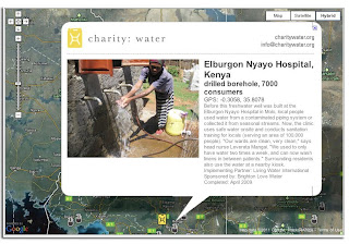
Charity:Water uses the Google Maps API to show donors precisely where the money they contributed was allocated. After donating, donors receive geographic coordinates to view the location of a well to which they’ve contributed, and they can also view pictures of people accessing clean drinking water as a result of their contribution.
Applications to the Google Earth Outreach Developer Grants program will be accepted until May 26, 2011. More details of the program, project requirements and eligibility can be found on the Google Earth Outreach Developer Grants page. Apply today!
Over the years, the Google Earth Outreach team has seen hundreds of maps that nonprofits are using to change the world for the better. We’ve also talked to just as many nonprofits who have a great idea for a map they want to create, but don’t have people on their team with enough technical skills to create it.
Today, we’re excited to announce the Google Earth Outreach Developer Grants program, supporting selected projects from eligible nonprofit organizations that are using Google’s mapping technologies in novel, innovative ways to make the world a better place.
Through this program, non-profit organizations from all over the world will have an opportunity to receive up to $20,000 that will help turn their mapping ideas to support their causes into a reality. Numerous nonprofits have already used Google Earth to raise awareness about an issue or cause that demonstrate innovation and creativity. The US Holocaust Memorial Museum and partners created the Crisis in Darfur Google Earth layer, which utilized Google Earth’s high-resolution satellite imagery to document the burning of villages, destruction of communities and livelihoods as a result of the genocide in Sudan. The presentation of refugee stories and testimonials in a map visualization brought 26 times the usual number of visitors to the USHMM’s “How Can I Help?” section of the website.
Charity:Water uses the Google Maps API to show donors precisely where the money they contributed was allocated. After donating, donors receive geographic coordinates to view the location of a well to which they’ve contributed, and they can also view pictures of people accessing clean drinking water as a result of their contribution.

Charity:Water connects donors to well sites all over the globe.
Applications to the Google Earth Outreach Developer Grants program will be accepted until May 26, 2011. More details of the program, project requirements and eligibility can be found on the Google Earth Outreach Developer Grants page. Apply today!
Friday, April 29, 2011
Celebrating Arbor Day with Save the Redwoods League and Google Earth
(Cross-posted from the Official Google Blog)
From time to time we invite guests to post about topics of interest and we’re pleased to have Emily Limm join us for U.S. Arbor Day. Emily is the science director for the non-profit Save the Redwoods League and is studying the impact of climate change on the redwood forests of northern California. To raise awareness about the League’s research, she worked with Google Earth Outreach to model old-growth redwoods on Google Earth. In this post, Emily shares her ideas on how technology and citizen science can help scientific research. -Ed.
Today is U.S. Arbor Day, a holiday established 120 years ago to celebrate our often under-appreciated forests, which provide us with necessities like clean air and drinking water as well as small pleasures like shade for a summer’s day picnic or a beautiful place to hike with crunchy leaves underfoot. Arbor Day holds special meaning for me because I spend most of my time in the coastal redwood forests of California, working to protect the world’s tallest tree species.
Over the past few months, Save the Redwoods League and the Google Earth Outreach team have collaborated to create 3D models of the old-growth redwood forest in Jedediah Smith Redwoods State Park in northern California, so you can now take a virtual hike among the ancient trees and cruise over towering treetops. Explore the park by activating the 3D trees layer in Earth (under 3D Buildings) and searching for [jedediah smith redwoods state park, ca]. Tilt your view angle toward the horizon to make the trees appear. You can download the KML file for the narrated tour about redwoods to view in Google Earth, or watch the video version below:
In order to protect redwoods in Jedediah Smith and elsewhere, my colleagues and I are working to collect data on geographic regions where the trees are currently thriving to determine how future forests will fare in our changing climate. A critical piece of our work is collecting and comparing field observations of redwoods across different climates, but we need more data to draw strong conclusions—and that’s where you come in.
Today, Save the Redwoods League is launching our citizen science project Redwood Watch, powered by iNaturalist.org, a platform for recording, organizing and mapping nature observations. By sharing a simple digital photograph of a redwood tree and the time and location where the picture was taken, you can help the League track and monitor the species. If you know of a redwood tree—perhaps in your own backyard or in a nearby park—you can use the free Redwood Watch iPhone application or your own camera to take a photo, add a comment and submit it online. iNaturalist stores your observation and, if geographical coordinates weren’t captured automatically, uses the Google Maps APIs to assign them to your photo. With your geolocated observation, we can zoom out and analyze your observation in the context of global environmental and climatic patterns.

The more field observations Save the Redwoods League collects, the better we’ll understand what climate makes a healthy redwood today, and predict where the redwood forests of tomorrow will thrive. We hope to see you on the Redwood Watch.
Happy Arbor Day from Save the Redwoods League and Google Earth!
Note: There are plenty of parallel projects going on around the world, so if you don’t live near redwoods, consider participating in one of the other iNaturalist.org citizen science projects.
From time to time we invite guests to post about topics of interest and we’re pleased to have Emily Limm join us for U.S. Arbor Day. Emily is the science director for the non-profit Save the Redwoods League and is studying the impact of climate change on the redwood forests of northern California. To raise awareness about the League’s research, she worked with Google Earth Outreach to model old-growth redwoods on Google Earth. In this post, Emily shares her ideas on how technology and citizen science can help scientific research. -Ed.
Today is U.S. Arbor Day, a holiday established 120 years ago to celebrate our often under-appreciated forests, which provide us with necessities like clean air and drinking water as well as small pleasures like shade for a summer’s day picnic or a beautiful place to hike with crunchy leaves underfoot. Arbor Day holds special meaning for me because I spend most of my time in the coastal redwood forests of California, working to protect the world’s tallest tree species.
Over the past few months, Save the Redwoods League and the Google Earth Outreach team have collaborated to create 3D models of the old-growth redwood forest in Jedediah Smith Redwoods State Park in northern California, so you can now take a virtual hike among the ancient trees and cruise over towering treetops. Explore the park by activating the 3D trees layer in Earth (under 3D Buildings) and searching for [jedediah smith redwoods state park, ca]. Tilt your view angle toward the horizon to make the trees appear. You can download the KML file for the narrated tour about redwoods to view in Google Earth, or watch the video version below:
In order to protect redwoods in Jedediah Smith and elsewhere, my colleagues and I are working to collect data on geographic regions where the trees are currently thriving to determine how future forests will fare in our changing climate. A critical piece of our work is collecting and comparing field observations of redwoods across different climates, but we need more data to draw strong conclusions—and that’s where you come in.
Today, Save the Redwoods League is launching our citizen science project Redwood Watch, powered by iNaturalist.org, a platform for recording, organizing and mapping nature observations. By sharing a simple digital photograph of a redwood tree and the time and location where the picture was taken, you can help the League track and monitor the species. If you know of a redwood tree—perhaps in your own backyard or in a nearby park—you can use the free Redwood Watch iPhone application or your own camera to take a photo, add a comment and submit it online. iNaturalist stores your observation and, if geographical coordinates weren’t captured automatically, uses the Google Maps APIs to assign them to your photo. With your geolocated observation, we can zoom out and analyze your observation in the context of global environmental and climatic patterns.

An observation of a coast redwood submitted to the Redwood Watch on iNaturalist.org.
The more field observations Save the Redwoods League collects, the better we’ll understand what climate makes a healthy redwood today, and predict where the redwood forests of tomorrow will thrive. We hope to see you on the Redwood Watch.
Happy Arbor Day from Save the Redwoods League and Google Earth!
Note: There are plenty of parallel projects going on around the world, so if you don’t live near redwoods, consider participating in one of the other iNaturalist.org citizen science projects.
Post Japan Earthquake panoramas in Google Earth
In an effort to continue to help keep people informed about the extent of the tragedy that has recently struck Japan, Google Earth has added panorama photos of post-earthquake zones. These photos come from our partner 360cities and can be found in the “Photos” layer in Google Earth, along with other 360cities and Panoramio photos. These dramatic panorama photos are part of the work of photographer, Akila Ninomiya.
In March 2011, Mr. Ninomiya took his camera and bravely ventured into the heart of post-earthquake zones in Iwate Prefecture, Japan. He documented earthquake and tsunami damages in cities including Rikuzen-Takada, Kamaishi, Osawa, Miyako, Settai, and Omoto.
Mr Ninomiya didn’t just take pictures. He took 360 degree panoramas, which give unique perspectives to the extent and severity of this unprecedented natural disaster.
To see his collection in Google Earth, make sure you have the “Photos” layer turned on. Then fly to any of the cities mentioned above, eg. Ofunato, Japan. You will see a number of orange colored photo placemarks. Click on one of them and you will see a picture like the one below:

To see the 360 degree view, click on the center picture in the balloon and it will take you into the panoramas. If you wish to view the post earthquake panoramas only, download this KML collection and open it in Google Earth.
These panoramas were taken as part of a non-profit Japan Pano Journalism Project, which aimed to document the 2011 Japan Earthquake damage and recovery with 360º panoramic photography.
Wednesday, April 27, 2011
A royal view of the wedding procession, right in your browser
As we get closer to the wedding day, we’ve also featured a few highlights along the procession route for you to explore in 3D using Google Maps with Earth View. If you have the Google Earth plug-in installed, you can get started viewing these spots though an immersive tour right away, or you can download the Google Earth plug-in to explore Google Maps in 3D.
With one click, you can travel to Buckingham Palace, fly to an aerial perspective of Westminster Abbey, or get a clock-level view of Big Ben and the Houses of Parliament. Get started seeing these and other highlights at maps.google.com/royalwedding.

Houses of Parliament & Big Ben, London
Whatever way you're celebrating on Friday, we hope this rich data of London in Google Earth and Google Maps brings you that little bit closer to this historic event.
Live from space: You talk to Commander Mark Kelly and the Endeavour Crew
(Cross-posted from the YouTube Blog)
UPDATE 4/29: NASA has scrubbed the launch attempt today due to a technical problem. We'll provide an update here on the live streamed launch and live interview, and you can follow NASA updates here.
We’ve always jumped at the chance to bring the wonders of space a little closer to home. We’ve announced a Moon office, a Moon race and an expedition to Mars and brought many nooks and crannies of the universe to Google Earth—Sky, Moon, Mars, NASA images and a Hubble tour, to name a few.
On Friday, April 29, the crew of STS-134 will launch into space for the final mission of Space Shuttle Endeavour and we want to give you the chance to connect with them. On May 2, NASA Commander Mark Kelly and his crew will take your questions live from space on YouTube. PBS NewsHour will live stream the interview from its YouTube channel with veteran space reporter Miles O’Brien curating and asking your questions to the crew.
Starting today, you can visit www.youtube.com/pbsnewshour to submit a video or written question for the crew of STS-134 to be used in the live interview and vote for your favorite questions. You can also submit questions on Twitter with the hashtag #utalk2nasa. Don’t be shy—if you’re most curious about how to prepare for a spacewalk or wondering if the astronauts have a speech prepared for an extra-terrestrial encounter, this is your chance to find out. Here’s a video from PBS and Miles O’Brien to inspire you:
A few suggestions before submitting your questions:
To get the full experience of STS-134, you can also watch a live stream of the shuttle launch on Friday April 29 starting at 3:47pm ET at www.youtube.com/pbsnewshour. Both the launch and the interview will be available for archived viewing.
Houston, we’re ready for lift-off.
UPDATE 4/29: NASA has scrubbed the launch attempt today due to a technical problem. We'll provide an update here on the live streamed launch and live interview, and you can follow NASA updates here.
We’ve always jumped at the chance to bring the wonders of space a little closer to home. We’ve announced a Moon office, a Moon race and an expedition to Mars and brought many nooks and crannies of the universe to Google Earth—Sky, Moon, Mars, NASA images and a Hubble tour, to name a few.
On Friday, April 29, the crew of STS-134 will launch into space for the final mission of Space Shuttle Endeavour and we want to give you the chance to connect with them. On May 2, NASA Commander Mark Kelly and his crew will take your questions live from space on YouTube. PBS NewsHour will live stream the interview from its YouTube channel with veteran space reporter Miles O’Brien curating and asking your questions to the crew.
Starting today, you can visit www.youtube.com/pbsnewshour to submit a video or written question for the crew of STS-134 to be used in the live interview and vote for your favorite questions. You can also submit questions on Twitter with the hashtag #utalk2nasa. Don’t be shy—if you’re most curious about how to prepare for a spacewalk or wondering if the astronauts have a speech prepared for an extra-terrestrial encounter, this is your chance to find out. Here’s a video from PBS and Miles O’Brien to inspire you:
A few suggestions before submitting your questions:
- Video questions are preferred, and should be a max of 20 seconds long
- Speak clearly and film in a place with minimal background noise. Keep the camera as still as possible and ask the question directly to the camera
- Look through NASA videos on YouTube about STS-134 to learn more about the mission and crew
To get the full experience of STS-134, you can also watch a live stream of the shuttle launch on Friday April 29 starting at 3:47pm ET at www.youtube.com/pbsnewshour. Both the launch and the interview will be available for archived viewing.
Houston, we’re ready for lift-off.
Tuesday, April 26, 2011
Imagery Update - Week of April 25th
The Google Earth and Google Maps Imagery Team has just published it’s latest batch of satellite and aerial imagery and as always, there’s all kinds of fascinating sites and features to see.
This release will be our last for April and this month, in particular is always associated in the northern hemisphere with spring and new beginnings. We can trace the meaning of the word April to the latin word aperire, "to open," and what better way to describe “open” than the start of another Major League Baseball season! Below you can see in high-resolution glory, the 2010 World Champion San Francisco Giants warming up at their Scottsdale, Arizona spring training park for opening day and defense of their title. In this image, they were hosting the Milwaukee Brewers. As the Giants’ home field is only an hour away from Google’s HQ in Mountain View, they are often the talk of choice in our offices!

Scottsdale Stadium, Scottsdale, Arizona
Below is another example of new beginnings. In this high-res aerial example, we can see Plymouth Rock (lower left), landing site of English Separatists and Anglicans looking for a new life, and the Mayflower 2 (upper right), a replica of their ship the Mayflower, both of which are located in Plymouth, Massachusetts.

Plymouth Rock, Plymouth, Massachusetts
Finally, here’s an aerial image of the Sendai Airport in Sendai, Japan as they’re preparing to re-open. To see how the clean-up and rebuilding has progressed at the airport and adjoining neighborhoods, use Google Earth’s Historical Imagery slider to see earlier post-quake imagery of the area. It’s impressive to see.

Sendai Airport, Sendai, Japan
As always, these are but a few examples of the types of features that can be seen and discovered in our latest batch of published imagery. Happy exploring!
High Resolution Aerial Updates:
USA: Phoenix, Tuscon, Albuquerque, Amarillo, Wichita, Austin, Cape Cod
Japan: Sendai
Countries/Regions receiving High Resolution Satellite Updates:
Antarctica, Armenia, Australia, Azerbaijan, Brazil, Burkina Faso, Canada, Chad, China, Croatia, Egypt, England, France, Georgia, Germany, Haiti, India, Israel, Italy, Japan, Kazakhstan, Madagascar, Mexico, Morocco, New Zealand, Nigeria, North Korea, Norway, Pakistan, Philippines, Poland, Romania, Russia, Saudi Arabia, Scotland, Senegal, Slovakia, Spain, Sweden, Turkey, United Arab Emirates, United States, Uruguay, Western Sahara, Yemen, Zambia
These updates are now available in both Google Maps and Google Earth. To get a complete picture of where we updated imagery, download this KML for viewing in Google Earth.
Thursday, April 21, 2011
A new photo browsing experience in Google Earth
Google Earth users love flying around the globe and checking out beautiful photographs in the “Photos” layer. Whether you are a photography fan or simply want to check out images of a place you'd like to visit, we’re pleased to announce a new photo browsing experience in Google Earth. With the new photo cluster feature, you can browse through several photos more easily and quickly.
To start, make sure the “Photos” layer is checked in the left layers panel and zoom down to your area of interest.

As an example below, check out the Golden Gate Bridge in San Francisco, CA. You will see photo icons on top of the satellite images. The larger photo icons indicate larger collections or clusters of photos. Click on any photo icon to open the Photos window.


Whether you’re deciding between Paris, Beijing or Venice for a nice vacation or simply want to go on a quick virtual getaway after a long day, we hope this new way of viewing photos in Google Earth helps bring places around the world to your fingertips.
If you’d like to contribute to our efforts of building a virtual atlas of the real world and have amazing photos you’d like to share, you can do so by uploading them to Panoramio.com.
Happy viewing!
Wednesday, April 20, 2011
Bringing Google’s Cloud technology to Google Earth & Maps Enterprise
Our vision for Google Earth and Google Maps has always been to create a digital mirror of the world where any user, anywhere, and from any device or platform can access current, authoritative, accurate, and rich information about the world around them. In order to provide fast and timely maps to our users, we’ve developed powerful geo infrastructure that lets us process and serve petabytes of imagery and basemap data to hundreds of millions of users.
We frequently hear requests from governments and businesses - some of whom use our existing Enterprise Earth & Maps products today - that they would like to have greater access to some of the infrastructure we’ve built in order to more easily store their geospatial data in the cloud and more easily build and publish maps for their users.
Today we announced Google Earth Builder, which continues the spirit of providing more access to Google’s core infrastructure, such as Google App Engine and Google Exacycle.
Google Earth Builder is an Enterprise mapping platform powered by Google’s cloud technology. We’ve built Google Earth Builder with the idea that any organization with their own mapping data - be it terabytes of imagery or just a few basemap layers - should be able to upload and manage that data in the cloud. They can use Google’s scalable infrastructure to process and securely serve it through familiar Google Earth and Maps interfaces to their users.
Our goal for Google Earth Builder is to enable Enterprises that work with geospatial data and create online maps to be able perform these tasks in the cloud. Over time we anticipate providing access to more and more of our geo infrastructure through Google Earth Builder, so businesses have more options for how to process, publish and analyze their geospatial data. We’re excited to launch Google Earth Builder in Q3, and in the meantime if you are interested in learning more then please get in touch.
Friday, April 8, 2011
Get a better view of mountains in Google Earth
 Let’s fly to Mount Everest, the highest mountain on the planet, to see one of the latest features. A green icon (
 ) will now be visible from high up.
Click on the green icon to view information about this mountain. Below is the bubble that will appear when you click on Mount Everest.

In the “Elevation Profile” section, you can view elevation cross-sections of the mountain in four directions (click on the links labeled “S-N”, “W-E”, “NW-SE”, “SW-NE” to change the cross-section views in the direction of your choice). The cross section is shown as a black line on the shaded relief image of the mountain, viewed on the right-hand side.
We're also excited to show off the tours created for each and every mountain. Click on the "Fly on a tour" link to download a KML tour. Hit the "Play" icon once the tour has downloaded and you'll be taken to a vantage point near the peak and flown in a circle to take in the views. Below is a YouTube video showing the tour for the Matterhorn.
We’ve also added hundreds of thousands of new labels for water bodies all over the world. Click on the “Water Bodies” label just underneath “Mountains” in the layer panel to see new labels for seas, bays, lakes, and reservoirs (rivers are not yet labeled).

We hope these changes will help enhance the use of Google Earth for education, learning, and exploring.
Sunday, April 3, 2011
Pausing the Real-World Sightings experiment
[Cross-posted from the Google SketchUp Blog]
On Friday we prematurely launched a feature called “Real-World Sightings,” showcasing fantastical creatures our users have spotted around the world. We’ve rolled back the test, but wanted to share an explanation in case you came across any surprising images in Google Earth and Google Maps.
We’re always working to provide an up-to-date, accurate reflection of the real world through our products. On Friday we learned of many additional sightings through reports submitted by our users, and we have decided to pause the beta until we can provide more comprehensive coverage of these mystical creatures.
For those of you who are curious about this brief experiment, check out the slideshow below to see all of the images and the locations included in the test.
We’d also like to take a moment to thank the Google SketchUp users who helped us create the 3D models for this experiment: Aerilius, Athinaios, Bdhy, BerylDrue, Fingerz, Jan Wesbuer, KangaroOz, NESUA, and Zoungy.
Posted by Scott Shawcroft, Software Engineer
Friday, April 1, 2011
Geographic Stars Compete in the National Geographic Bee State Championships
Understanding the world around you is imperative, especially since technology has made it easier and fun to explore places you could, otherwise, only imagine. Being geographically literate helps you interpret the plethora of information that comes your way each day (and that’s no joke)! Without the perspective of knowing where you are or where things happen, you can find it difficult to navigate your way through it all. That is why Google is excited and proud to sponsor the National Geographic Bee for the third year, which sparks student interest in geography.
Last fall, over four million students started preparing for the 2011 Bee. Today, the students who have progressed to the state bee level, will compete for one of the coveted 54 spots at the finals in Washington DC in May. It’s not as simple as memorizing a list of capitals or identifying places on a map. These geographic black belts answer tough questions about human, environmental, physical, and regional geography.
The love of geography is a great asset for these students as they continue their education and careers. It might also lead them to a life of exploration and adventure. We asked a few famous explorers why geography is important to them and how they use Google Earth. Watch our Geography video below to hear their great insight:
We wish all of the competitors the best of luck!
Real-World Sightings, Now in Google Earth and Maps
[Cross-posted from the Google SketchUp Blog]
Today we’re premiering our new Real-World Sightings series on Google Earth and Google Maps. As part of this experiment, we’ve added 10 images to the map based on stories we’ve heard from our users. As is common with betas, we’ll evaluate interest and engagement with this feature before determining future rollout plans.
It all started with a recent visit to my friend Nessie in Boston. As I crossed the bridge into town, the car in front of me stopped short so I slammed on the brakes. The cars next to me were also stopped, so I got out to see what was causing the back up.
There was a huge, red lobster sitting on the bridge.

He wasn’t scared or hostile. In fact, he seemed quite amused as a few brave drivers navigated around his over-sized legs to successfully cross the bridge. Soon everyone’s fear and alarm gave way to wonder and surprise.
As I made the journey under the giant crustacean's torso, I was reminded how much bigger the world is than we often realize. I made it to Nessie’s place in Boston safely and got to thinking: the world must be full of magical stories like this.
My friends at Google agreed, and so we asked users from around the world to share stories of the strange and delightful things they’ve seen. We were surprised at how many reports we received, so today we’re adding a new feature to Google Maps and Earth: Real-World Sightings. People have witnessed fantastical creatures in every corner of the globe, and in our effort to mirror the real world as completely as possible, we have decided to start including these eyewitness reports on the map.
So if you happen to run into a dragon or alien today in Google Earth (make sure you have 3D Buildings turned on) or Maps, don’t be alarmed. Instead, we encourage you take a few minutes to look for other creatures that have been reported in places all across the world. We’ll tweet some tips to help you get started finding these images on our Twitter handle @GoogleMaps, so follow along throughout the day to spot some fun things you may have thought only existed in legends and fairy tales!
Posted by Dave Barth, Product Manager
Thursday, March 24, 2011
Imagery Update (and Kansas Basketball)
We’re in the middle of college basketball Madness here in the U.S. and the best is yet to come. Tomorrow night, the Kansas Jayhawks will play the Richmond Spiders in a Sweet Sixteen match-up at the Alamodome in Texas. I’ll proudly admit that I’m a Kansas fan and hoping to see my home team make it to the Finals. But I’m not the only college hoops fan at Google. In fact, our Geo team put together a special page that shows an up-to-date schedule with schools and stadiums.
In our latest imagery push, we (coincidentally) added new imagery of Lawrence, Kansas and a new 3D model of the Allen Fieldhouse, possibly the best basketball venue on Earth. As a longtime Lawrence resident and KU alumnus, I still remember my first games in the “Phog” when I was in junior high school, watching from the upper bleachers. The Fieldhouse has aged well with the new Booth Family Hall of Athletics and the parking additions.


High Resolution Aerial Updates:
USA: Boca Raton, FL; West Palm Beach, FL; Port St Lucie, FL; Crystal River, FL; Ocala, FL; Gainesville, FL; Tallahassee, FL; Valdosta, GA; Savannah, GA; Jackson County, GA; Bedford County, PA; Cumberland County, PA; Manhattan, KS; Lawrence, KS
Wales: Northern Half
Scotland: Hawick
Japan: Tokyo; Kawasaki; Yokosuka
Australia: Sydney, Brisbane, Canberra
Countries/Regions receiving High Resolution Satellite Updates:
Antarctica, United States, Canada, Mexico, Cuba, Haiti, Dominican Republic, El Salvador, Panama, Bolivia, Paraguay, Brazil, Argentina, South Africa, Madagascar, Namibia, Zimbabwe, Zambia, Angola, Tanzania, Kenya, Burundi, Rwanda, Democratic Republic of the Congo, Uganda, Ethiopia, Sudan, Central Africa, Niger, Ivory Coast, Togo, Liberia, Senegal, Morocco, Algeria, Tunisia, Egypt, Israel, Jordan, Syria, Saudi Arabia, Bahrain, Qatar, United Arab Emirates, Kuwait, Yemen, Iran, Pakistan, Tajikistan, India, Bangladesh, China, Myanmar, Thailand, Taiwan, North Korea, Japan, Mongolia, Indonesia, Australia, New Zealand, Russia, Georgia, Armenia, Azerbaijan, Turkey, Greece, Bulgaria, Romania, Ukraine, Hungary, Austria, Poland, Croatia, Italy, Germany, Switzerland, France, Spain, Portugal, Ireland, Norway, Sweden, Finland, Greenland
These updates are now available in both Google Maps and Google Earth. To get a complete picture of where we updated imagery, download this KML for viewing in Google Earth.
Update, March 25, 1:30 PM PDT: Topeka, KS is not included in this batch of updated imagery.
Tuesday, March 22, 2011
Marine debris is everyone’s problem
Marine debris is a global problem affecting everything from the environment to the economy; from fishing and navigation to human health and safety; from the tiniest coral polyps to giant blue whales. Marine debris also comes in many forms, from a cigarette butt to a 4,000-pound derelict fishing net. To help show the breadth of this problem, the National Oceanic and Atmospheric Administration (NOAA) has created a KML tour for Google Earth. Download this tour in the Ocean Gallery. Or, watch the Google Earth video below to learn more about the marine debris.
The Fifth International Marine Debris Conference will take place March 20-25, 2011, in Honolulu, Hawaii. NOAA and the United Nations Environment Programme are co-organizers of the conference which will bring together international marine debris researchers, natural resource managers, policy makers, industry representatives, and the nongovernmental community. This conference will highlight research advances, allow sharing of strategies and best practices to assess, reduce, and prevent the impacts of marine debris, and provide an opportunity for the development of specific bilateral or multi-country strategies.

Thursday, March 17, 2011
Take a festive tour for St. Patrick’s Day
For me, this holiday is not just about enjoying a feast with friends (even though I love baking the soda bread) – it’s also about going back to my Irish family heritage. Since Google Maps with Street View is available in Ireland, I went back to one of my favorite spots, Roundstone fishing village, that I visited two years ago. The winding, coastline roads are just as I remember them.
To get into the spirit, you can also play a Google Earth Tour to visit special places in Ireland and places around that world that celebrate this holiday. Fly to the Kilkenny Castle in 3D, see an exit ramp in the shape of a Shamrock, and visit an Irish village. We’ve also added the tour to the Google Earth Gallery so you can download the file and explore on your own.

Every year, the Chicago river turns green for the St. Patrick’s Day Parade
For this Irish celebration, you can also add your own 3D buildings to Google Earth. With Google Building Maker, find your spot in Dublin, Ireland and quickly model a building using our photos. Or, try your hand at SketchUp and add your own creations to Google Earth anywhere in the world (buildings above were created by users).

So now we’ve given you plenty of ideas on how to celebrate this Irish holiday. Happy St. Patrick’s Day!
Monday, March 14, 2011
Baseline to baseline, we’ve got the basketball games covered
[Cross-posted from the Official Google Blog]
Do you hear the dribble on the court and the chanting of the fans? Following an action-packed week of buzzer beaters, the 2011 NCAA® Championship here in the U.S. promises to be as exciting as ever.
As a college hoops fan, I often wish I could experience the games sitting in the arenas—and I’m sure I’m not alone. This year, our college basketball tournament map lets you get as close as you can to the games without leaving your desk thanks to 3D models of the tournament’s 14 arenas. Take a virtual tour of the venues by watching the video below, or download this tour and open it in Google Earth.
Plus, we’ve created a special page for you to keep track of all the excitement during the next few weeks. You can see an up-to-date tournament schedule, explore the college campuses in Street View and click through to watch the actual games on NCAA® March Madness on Demand®. You can also create a bracket using Google Docs, read Google News articles on the games and download basketball apps from the Chrome Web Store. It’s all here (along with a fun surprise) at www.google.com/collegebasketball2011.
And since there’s been a long-running debate over whether teams playing closer to their home court have an advantage, we added a “Distance Tool” on the map to make it easier to measure how far schools have to travel from game to game. We’ll see how things play out, but the defending champion Duke Blue Devils may have to travel more than 2,000 miles to Anaheim if they win their first two games.

As my friends always say when we can’t wait for the tournament to begin, “Send it in, Jerome!” May your favorite school reach the finals and we hope you enjoy all the basketball fun at www.google.com/collegebasketball2011.
Do you hear the dribble on the court and the chanting of the fans? Following an action-packed week of buzzer beaters, the 2011 NCAA® Championship here in the U.S. promises to be as exciting as ever.
As a college hoops fan, I often wish I could experience the games sitting in the arenas—and I’m sure I’m not alone. This year, our college basketball tournament map lets you get as close as you can to the games without leaving your desk thanks to 3D models of the tournament’s 14 arenas. Take a virtual tour of the venues by watching the video below, or download this tour and open it in Google Earth.
Plus, we’ve created a special page for you to keep track of all the excitement during the next few weeks. You can see an up-to-date tournament schedule, explore the college campuses in Street View and click through to watch the actual games on NCAA® March Madness on Demand®. You can also create a bracket using Google Docs, read Google News articles on the games and download basketball apps from the Chrome Web Store. It’s all here (along with a fun surprise) at www.google.com/collegebasketball2011.
And since there’s been a long-running debate over whether teams playing closer to their home court have an advantage, we added a “Distance Tool” on the map to make it easier to measure how far schools have to travel from game to game. We’ll see how things play out, but the defending champion Duke Blue Devils may have to travel more than 2,000 miles to Anaheim if they win their first two games.
As my friends always say when we can’t wait for the tournament to begin, “Send it in, Jerome!” May your favorite school reach the finals and we hope you enjoy all the basketball fun at www.google.com/collegebasketball2011.
Saturday, March 12, 2011
Post-earthquake images of Japan
In response to the devastating earthquake and subsequent tsunami that struck Japan, we’ve worked with our satellite imagery providers to get the latest available data of the areas affected most.
To view this high-resolution imagery, courtesy of our partners at GeoEye, download this KML file and explore it in Google Earth. You can also explore the imagery with Google Maps, or have a look at this Picasa album of before-and-after shots. Here’s a sample:
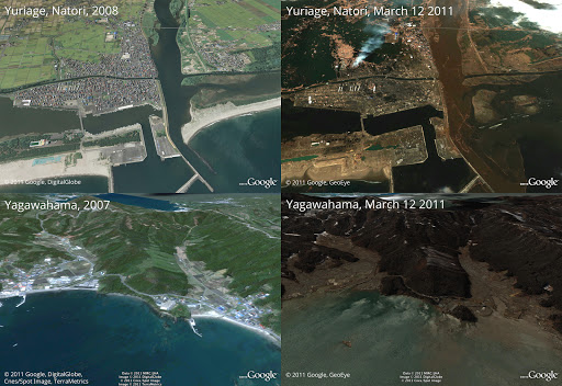
Before and after the earthquake and tsunami. Above is Yuriage in Natori, below is Yagawahama; both are in Miyagi prefecture. High-resolution version of this photo.
We’re working to provide this data directly to response organizations on the ground to aid their efforts. We hope this new updated satellite imagery is valuable for them as well as everyone else following this situation to help illustrate the extent of the damage.
You can find more information regarding the disaster and resources for those in need at our Crisis Response page in English and Japanese. You can also follow @earthoutreach on Twitter to stay up to date with our mapping and imagery efforts.
Wednesday, March 2, 2011
Ski the slopes in Google Earth
Heading for the slopes this winter? Put on your warm hat, grab your mittens, rent those skis, and bundle up in your warmest jacket … and don’t forget your GPS tracking device! When you hit the slopes this winter, track your route down the slopes and share your animated ski tracks in Google Earth.
This past weekend, a couple of Googlers and I headed up to Lake Tahoe, CA with a few GPS devices. We recorded some of our favorite ski runs and animated our tracks in Google Earth. You can check out all of our animated tracks in the video below, or download the KML to play the tracks in Google Earth.
Capturing a GPS track is easy -- just make sure that you have a GPS tracking device on hand before you hit the slopes. A Garmin® or Magellan® device works best, but you can also use a GPS tracking application on most mobile phones. My Tracks on Android works well, or if you have an iPhone, try using MotionX-GPS.
When you get to the top of the mountain, start recording your track. Place your phone or device in an outside pocket, preferably separate from another device. When you get to the end of your run, stop the track. Or, if you prefer to track the entire day, keep the GPS track running. Most of us decided to keep our tracks running the entire day so we could focus entirely at the task at hand - skiing.
After a full day of skiing and snowboarding, we grabbed some hot cocoa from the lodge and headed home, where we imported our tracks into Google Earth. My fellow Googler, David captured his GPS data with My Tracks, and imported the data by dragging and dropping a .gpx file into Google Earth. We then started playing with the new GPS track animation feature launched in Google Earth 5.2, and customized and animated our ski tracks just the way we wanted them. Take a look below at how David customized the line color and label of his track. (He even personalized the tracking icon to make it look like an actual skier!)

We also animated our tracks by creating a tour, which we customized by changing the camera tilt angle, camera range, and tour speed in the preferences dialog. Here’s a helpful hint: if you want it to seem like you went faster, create a tour with a high speed setting to view your track in fast-forward.
Next, we used Google Earth’s Elevation Profile feature to get a better idea as to the difficulty of the runs we skied that day. With GPS tracks, the feature can show both an elevation profile (shown below in red), and a speed profile (shown below in blue). Looking at the red elevation profile below, as you ski around the mountain, there is quite a bit of elevation change. We then counted the total number of peaks in our track’s elevation profile to discover how many runs we skied in one day.

Don’t ski or snowboard? Don’t worry! You can track other exciting winter activities in Google Earth. I’ve never been a big skier, but I love to snowshoe and go dog sledding. Check out the dog sledding tour I created below, paired with a photo of my actual dog sledding experience.


We had so much fun tracking our winter adventures in Tahoe that we even tracked our bus ride home to San Francisco. We were sorry to leave, but I knew we’d be back to trace new paths in the mountains next year -- or even next weekend!
This past weekend, a couple of Googlers and I headed up to Lake Tahoe, CA with a few GPS devices. We recorded some of our favorite ski runs and animated our tracks in Google Earth. You can check out all of our animated tracks in the video below, or download the KML to play the tracks in Google Earth.
Capturing a GPS track is easy -- just make sure that you have a GPS tracking device on hand before you hit the slopes. A Garmin® or Magellan® device works best, but you can also use a GPS tracking application on most mobile phones. My Tracks on Android works well, or if you have an iPhone, try using MotionX-GPS.
When you get to the top of the mountain, start recording your track. Place your phone or device in an outside pocket, preferably separate from another device. When you get to the end of your run, stop the track. Or, if you prefer to track the entire day, keep the GPS track running. Most of us decided to keep our tracks running the entire day so we could focus entirely at the task at hand - skiing.
After a full day of skiing and snowboarding, we grabbed some hot cocoa from the lodge and headed home, where we imported our tracks into Google Earth. My fellow Googler, David captured his GPS data with My Tracks, and imported the data by dragging and dropping a .gpx file into Google Earth. We then started playing with the new GPS track animation feature launched in Google Earth 5.2, and customized and animated our ski tracks just the way we wanted them. Take a look below at how David customized the line color and label of his track. (He even personalized the tracking icon to make it look like an actual skier!)
Next, we used Google Earth’s Elevation Profile feature to get a better idea as to the difficulty of the runs we skied that day. With GPS tracks, the feature can show both an elevation profile (shown below in red), and a speed profile (shown below in blue). Looking at the red elevation profile below, as you ski around the mountain, there is quite a bit of elevation change. We then counted the total number of peaks in our track’s elevation profile to discover how many runs we skied in one day.
We had so much fun tracking our winter adventures in Tahoe that we even tracked our bus ride home to San Francisco. We were sorry to leave, but I knew we’d be back to trace new paths in the mountains next year -- or even next weekend!
Subscribe to:
Posts (Atom)