.:[Double Click To][Close]:.
Get Paid To Promote, Get Paid To Popup, Get Paid Display Banner


Showing posts with label photos. Show all posts

Friday, April 29, 2011

Post Japan Earthquake panoramas in Google Earth


In an effort to continue to help keep people informed about the extent of the tragedy that has recently struck Japan, Google Earth has added panorama photos of post-earthquake zones. These photos come from our partner 360cities and can be found in the “Photos” layer in Google Earth, along with other 360cities and Panoramio photos. These dramatic panorama photos are part of the work of photographer, Akila Ninomiya.

In March 2011, Mr. Ninomiya took his camera and bravely ventured into the heart of post-earthquake zones in Iwate Prefecture, Japan. He documented earthquake and tsunami damages in cities including Rikuzen-Takada, Kamaishi, Osawa, Miyako, Settai, and Omoto.

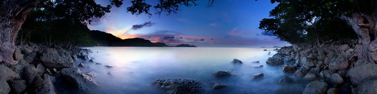
Mr Ninomiya didn’t just take pictures. He took 360 degree panoramas, which give unique perspectives to the extent and severity of this unprecedented natural disaster.

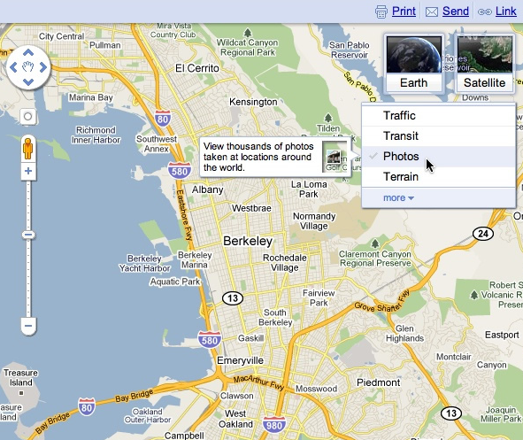
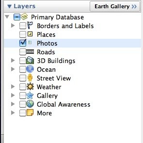
To see his collection in Google Earth, make sure you have the “Photos” layer turned on. Then fly to any of the cities mentioned above, eg. Ofunato, Japan. You will see a number of orange colored photo placemarks. Click on one of them and you will see a picture like the one below:


To see the 360 degree view, click on the center picture in the balloon and it will take you into the panoramas. If you wish to view the post earthquake panoramas only, download this KML collection and open it in Google Earth.

These panoramas were taken as part of a non-profit Japan Pano Journalism Project, which aimed to document the 2011 Japan Earthquake damage and recovery with 360º panoramic photography.

Thursday, April 21, 2011

A new photo browsing experience in Google Earth


Google Earth users love flying around the globe and checking out beautiful photographs in the “Photos” layer. Whether you are a photography fan or simply want to check out images of a place you'd like to visit, we’re pleased to announce a new photo browsing experience in Google Earth. With the new photo cluster feature, you can browse through several photos more easily and quickly.

To start, make sure the “Photos” layer is checked in the left layers panel and zoom down to your area of interest.


As an example below, check out the Golden Gate Bridge in San Francisco, CA. You will see photo icons on top of the satellite images. The larger photo icons indicate larger collections or clusters of photos. Click on any photo icon to open the Photos window.


To browse through the images in a collection, click on a photo in the filmstrip and use the “left” and “right” arrow keys on your keyboard to flip through them quickly.


Whether you’re deciding between Paris, Beijing or Venice for a nice vacation or simply want to go on a quick virtual getaway after a long day, we hope this new way of viewing photos in Google Earth helps bring places around the world to your fingertips.

If you’d like to contribute to our efforts of building a virtual atlas of the real world and have amazing photos you’d like to share, you can do so by uploading them to Panoramio.com.

Happy viewing!

Friday, February 4, 2011

Geotagging photos with Panoramio and Google Latitude

[Cross-posted from the Panoramio Blog]


It is 9 a.m. and the thermometer shows -15°C. I have a Nexus S with Google Latitude in my left pocket and my new Lumix LX-5 in the right one. I am in Davos and I am ready for a fantastic day of skiing when I decide to use the new feature of Panoramio: geotagging photos with Google Latitude.


Panoramio is a community photos website that enables digital photographers to geo-locate, store and organize their photographs -- and to view those photographs in Google Earth.


Google Latitude allows you to share your location with friends and view their location on a map. When enabled, Google Latitude History allows you to store your previous locations and this allows you to match your photos with the locations stored in Google Latitude History.


By combining Panoramio and Google Latitude your photos get geotagged automatically as the time stamp of the photos is matched with your location record in Google Latitude History. To use this feature you need to explicitly enable it in your Settings page in Panoramio. With your permission, Panoramio will access your Google Latitude History to find out your location at the time when your photos are taken, so make sure the time in your camera is correct and it matches the value you entered in the Panoramio Settings page.


Using Google Latitude while skiing allows you to find your friends when you get lost on the slopes, and at the same time it allows you to focus on taking nice photos not worrying about the location where you are taking them.


Mapping photos within the city is normally not a problem as you can easily remember street names, points of interest, etc. It is much more difficult to do it in the countryside and that is why I decided to give the feature a whirl while skiing in Davos:


Thanks to Google Latitude, my photos were geotagged just after uploading them in Panoramio. The day was great, snow was perfect, weather was amazing and when I arrived home my photos were already geo-positioned.


For more information about this feature please check our help content and as always we will be happy to hear your feedback in the Panoramio forum.

Monday, January 24, 2011

Share your photos about Places


When looking for information about a place on Google Maps, I immediately look for photos to help decide if it’s the right place for the occasion I have in mind. Whether looking for images of a restaurant’s cuisine, or getting a feel for the ambiance at a local bookstore, photos immediately help me learn more about a place.

A few months ago, we launched an improved photo viewer for Place pages to help you quickly and easily explore images of locations all over the world. Starting today, you can also contribute your own photos of places you've been to the growing collection of high-quality photos across the web.

The “Photos” section of the Place page now includes an "Upload a photo" link. This new link enables you to select an original photo on your computer and easily add it to the group of photos in the gallery.


The most useful photos are descriptive ones that help others experience or envision a place before they visit it in person. It might be a close-up of a popular dish, a wide shot of a business interior, or a picture of the outside of the building.

Photos that comply with our review guidelines will be available in Place page results for that particular business for you and any other potential customers to see. Users will also be able to explore these photos in search results across Google, Google Maps and Google Earth.

We’re eager to see the variety of photo styles and images our users share for everyone to view and enjoy.

Posted by Roland Kehl, Software Engineer

Wednesday, January 19, 2011

See more views with the new Google Maps widget


When we launched Google Maps, we had one layer -- the map. Since then, we’ve added more than ten different ways to explore the world around you, including photos, transit and traffic information, as well as satellite and terrain views. We’ve now updated the design so that you can more easily see and switch between the various viewing options that are available.

Suppose you’re planning to meet your friend for a concert at the Greek Theater in Berkeley, and you want driving directions to plan your trip from your apartment in San Francisco. When accessing Google Maps, you’ll see a new widget in the upper right corner that allows you to easily select from either the Maps, satellite or Earth view. In addition, the single widget icon showcases all the different layers available to you, enabling you to quickly see more detailed information just by mousing over the ones you want.


Since it’s nearly rush hour and traffic information would be useful, you select that layer by clicking on it in the widget:


Unfortunately, the traffic layer shows that there are heavy delays along your route. You wonder if taking public transit is a better option, so you turn off the traffic layer by clicking on it again, and turn on the transit layer instead:


Ah, it looks like there’s a Bay Area Rapid Transit (BART) station near your apartment and one near the Greek Theatre. Public transit it is! If you also want to find a local spot to grab dinner after the show, you could search for [restaurants] in the same Google Maps window. Your recently viewed searches will appear in the new widget, enabling you to easily see both your destination and search results at the same time. This makes it easy to find a place nearby.


We hope this new all-inclusive widget for accessing map types, layers and recently viewed searches improves your experience exploring and navigating to the places you want to go!

Update (11/20): Sorry for the delay, but the new widget for viewing map types, layers and recent searches will be available soon. We'll update this post again when the widget is live.

Update (1/24): The widget is now live for all users on Google Maps. We hope you’ll enjoy exploring all the useful information available right on the map!

Posted by Amanda Leicht, Product Manager

Friday, November 12, 2010

New panoramic photos in Google Earth


Viewing photos in Google Earth has long been a popular activity for avid virtual globe-trotters. It's one of the best ways to "visit" places all over the world without paying for a plane ticket or getting jet lag. Today, the Google Earth photo viewing experience just got better with the addition of panoramic images.

People using Google Earth will find a new "Photos" layer that includes not only the existing 2D photos from the Panoramio community, but also panoramic photos from around the world contributed by users of 360cities.net. These high-resolution panoramic photos are marked in Google Earth as red square icons. When you click on one of these icons, an info bubble containing an image appears, and clicking on the image again will take you into our photo viewing mode. You can then look around in 360-degree views and experience the place as if you’re standing right at the center of it.

new "Photos" layer on Google Earth


info bubble on Google Earth


These panoramic photos are shot by average people just like you and me. To contribute your panoramic photos, visit 360cities.net. We invite all users to become part of the community and mark your photo journey in Google Earth.

Check out some of the beautiful images now available right in Google Earth.

Golden Gate Bridge on Google Earth and on 360cities.net


Gapang Beach, Pulau Weh, Indonesia on Google Earth and on 360cities.net


Lion's Head, South Africa on Google Earth and on 360cities.net


Diving New Caledonia Amedee Island on Google Earth and on 360cities.net


Umag Asanas, Istria at sunset on Google Earth and on 360cities.net


Panthéon and Foucault pendulum, Paris on Google Earth and on 360cities.net


Posted by Wei Luo, Senior Geo Data Strategist

Monday, November 1, 2010

Announcing the Panoramio Photo Contest

The Panoramio community enables you to share your photos and explore them on Google Earth, Google Maps and other places. If you’ve never geo-tagged a photo, watch this video to learn how easy it is to add photos to the Panoramio layer in Google Earth.

Now you can add some excitement to your photo project and enter your photos to the monthly Panoramio Geotagged Photo Contest! Starting this month, we’ll be giving away the new Casio Hybrid-GPS camera EX-H20G to the winner of each category (Scenery, Heritage, Travel and Unusual Location). The Panoramio community reviews all of the submissions and votes for what they consider to be the best each month.


Casio’s new Hybrid-GPS camera combines a GPS engine with autonomic positioning made possible by a motion sensor. This makes geotagging easy—both outdoors and indoors.


If you haven’t joined the Panoramio community yet, try it out and don’t forget to participate in our monthly contest. To enter your photo, click on “Submit to the contest” and choose a category. Good luck and we can’t wait to see your photos!

Posted by Gerard Sanz, Panoramio Community Manager

Tuesday, October 26, 2010

Business Photos from Google are now on Place pages


Six months ago, we announced the pilot of a project to take photos of business interiors. Through this program, business owners located in the U.S., Australia and Japan could invite our photographers into their establishments to take high-quality images of their businesses. Excitement from interested business owners grew quickly, and we’ve since taken photos of businesses in about 30 cities.

Starting today, the images we’ve taken as part of the pilot can be viewed on the Place pages of participating businesses. Users and potential customers who look online for local businesses can now see more high-quality photos that give them a sense of what a place is really like. The photos may include the storefront, decor, layout, merchandise, food, signage about hours and accepted payment types, and other items that help people learn more about a business and decide if they want to go there. For example, if you’re looking for the perfect restaurant to make a good impression on a first date, the high-quality interior photos might help you decide if the ambiance and atmosphere of a particular place are right for the occasion you’re planning.

Here are a few examples of these high-resolution photos:

法善寺横丁 正弁丹吾亭, or Shoben Tango Tei, an authentic Japanese restaurant in Osaka, Japan


Pane e Vino, an award-winning Italian Restaurant in San Francisco, CA


Susan Avery Flowers and Event Styling, a wedding services, event planning and florist shop in Sydney, Australia

Business owners who worked directly with our photographers across these three regions will see the photos from Google on their Place page within the coming weeks. Thanks to all of you who welcomed us into your businesses. We’re continuing to take photos at more business locations, and urge others to let us know if you’d like us to visit you as well.

In the meantime, you can also upload your own photos and videos of your business by signing in to Google Places. By building out your Place page with visuals and other relevant business information - such as hours of operation, offers and more - you’ll help potential customers learn more about you and feel like they know what to expect when they actually walk through your doors.

Posted by Gadi Royz, Product Manager

Monday, October 4, 2010

Panoramio Stats: Where are my photos viewed?


Panoramio is a community photo-sharing site for geo-located images. Photos uploaded to Panoramio show up on its website, as well as other places such as Google Earth and Google Maps.

We’re excited to announce that detailed statistics are now available to users directly within their Panoramio account. Think of Panoramio Stats as a photo-specific version of Google Analytics for Panoramio - in other words, a powerful web analytics tool that helps you measure the performance of your photos. With this new feature, you can track the sites from which your photos have been viewed in visually appealing and intuitive reports.


These statistics are available for every photographer and surface granular information about each photo. For example, a reports for the last 30 days can be broken down by referral domain so photographers can see how many times their photos were viewed within Panoramio, on Google Earth, Google Maps, and through Panoramio’s Widget API.

Additionally, Panoramio Stats helps you identify your most recently viewed and most popular photos, and lets you know about new referral sites so you can track the latest online activity around your photos and figure out what types, styles or genres of your photos generate the most interest and help you improve your craft.

As always we’d love to hear your thoughts on this cool new feature, so feel free to leave us your comments in the Panoramio Forum.

Posted by Gyuri Dorko, Software Engineer

Tuesday, September 28, 2010

Revamping the Photo Layer in Google Maps


Here at Google, we love the experience of browsing photos on a map, and today it just got a lot easier. We have launched an update to the design of the Photo layer in Google Maps to provide you with a better experience when browsing your favorite places:


There are three main improvements in this latest update:

Firstly, we have made improvements to the density of the photos on the map, making it easier to see clusters of photos in popular locations. On the screenshot above, you can now well see that there are a lot more photos taken on the coast than there are inland.

Secondly, we’ve made the small thumbnails partially transparent, making it easier to see the underlying map, and helping you to stay oriented. On the screenshot above, the city and neighborhood labels are now more legible.

Finally, we are showing more information when you hover over a photo. Now, you can see a large thumbnail and the title of each image, so you can get a fast preview of what any photo looks like.

We’d love to hear your thoughts on the new layer, so feel free to leave us your comments in the Panoramio forum.

Jonah Jones, User Experience Designer, Google Maps

Wednesday, September 15, 2010

For your viewing pleasure: a new and improved way to explore online photos


When you’re curious about a new place - be it a restaurant that you haven’t yet tried or a popular tourist attraction you’re considering visiting on an upcoming trip - you may find it useful to see what that place looks like in advance. For this reason, Place pages make it possible to visually explore various locations by aggregating and displaying photos from around the web.

Today, we’re offering you a better, more streamlined way to view these photos. With this new feature, you can easily flip through a whole collection of photos and find the sites on the web that have relevant pictures of a given place. Photos that have been uploaded by our Panoramio or Google Places users will appear in high-resolution as an overlay when users click on them. For photos from other sources, you can easily click on a specific photo to see more and visit the site it comes from.


This simple and intuitive online album experience makes it easier to explore all the wonderful photographs of places all over the world. For example, the above photos on the Place page for Coit Tower in San Francisco really help bring the place to life since they’re shot from multiple angles and different times of day, and provide context about this landmark’s location in San Francisco.

If you’re interested in uploading your photos of places and making them more discoverable online, check out Panoramio, a great way to share geo-tagged photos on the Web.

By Sascha Häberling, Software Engineer

Tuesday, June 15, 2010

Let Pegman guide you to user photos

You may be familiar with the photos layer on Google Maps - it’s a great way to explore user generated photos from countries all over the world right within Google Maps. Over the last couple of years since launching this layer we’ve made various improvements so people can explore them more easily. Like being able to slide from a gorgeous view along the bank of the Seine at dawn to another at sunset, simply by clicking the dots. Today we have another great way you can take that round the world trip you always wanted.

Remember Pegman, the little orange man that you can drag and drop on to the map to jump into Street View images? As of today, he has a new trick up his sleeve. He’s becoming our official photo tour guide, helping you not only navigate our Street View imagery where it’s available, but also helping to highlight the amazing geo-located photos the Panoramio photo community has contributed, as well as public images from Picasa and Flickr. There are images from pretty much every corner of the globe, so there is almost no end of sights and scenes to keep you busy.

When you drag Pegman, you will now see small blue dots to show where user-contributed photos are available (they look a bit like the squares you see on our Wikipedia layer on maps).


If you drag Pegman over one of the blue dots, you get to see a preview of a photo taken at that location.


Then if you drop Pegman onto one of the blue dots, you will be able to view that image in our photo browser, which will let you navigate further into neighbouring pictures.


The photos you can explore this way are the same as those that you can find in the Maps photo layer, giving you a full interactive tour. It’s also a great way to explore images taken from places in out-of-the-way locations - say, the top of Half Dome in Yosemite National Park.


Dragging Pegman onto a photo is another handy way to see all the types of images available in Google Maps. So go ahead and let Pegman be your tourguide to parks, forests, lakes and more.


Wednesday, June 9, 2010

Seeing new sights with photo overlays


Sometimes you want to explore a place for yourself, and sometimes you want to get a sense of how other people experience it. With our newest update to User Photos available within Street View, you can seamlessly do both. Now when you’re browsing a location in Street View, you can see user-contributed photographs directly overlaid within the panorama.


The new feature places thumbnails of relevant photos on top of the Street View imagery when you click the “Photos” option at the top right of the panorama. When you move your mouse cursor over one of these thumbnails, a photo appears which matches the content of the panoramic view. Using the overlays you can quickly preview several photos without changing your viewpoint or losing track of where you were. And if you click on the photo, you enter our interactive photo browser to explore additional pictures taken by the community.

It is now even easier to inspect architectural details and close-up quirks, or see what is happening at a place at more than one time of the day. Start to explore this new world through the eyes of other travelers with some of these locations:

See the Bundesplatz fountains in action

Explore Ponte Vecchio in Florence from a new perspective

See the sun rise over Notre Dame

Wednesday, March 26, 2008

Add your own buttons to Picasa, upload photos all over the Web


If you've ever wanted to make your favorite software or website work with Google's Picasa software, there's a new Picasa Button API that lets you add your own buttons to the desktop interface.


The BlogThis! button in Picasa uses these APIs.

These buttons can send files to other applications on your PC, -- this tutorial (.zip) shows how to send files to Adobe Photoshop CS3 -- and they can also upload photos and movies to websites of your choice.

I'm most excited about our Web Uploader API. It uses a protocol we developed for posting photos to Blogger a couple years ago, and it shows a web-based preview of what you're going to upload before you send it. Using the web uploader, you can make user interfaces that feel more like sending an email and less like "Wait an hour to upload..." Picasa can also resize files before sending, saving time. There's some sample PHP code (.zip) to try out.

Also because these new buttons can be made by anyone, it means that there's no job too small for a Picasa button. You could make a button for your personal blog or for your major photo hosting service. See our demo video, which features Smugmug.

If you live near Mountain View, California, come out for Thursday's Youtube/Picasa Hackathon. We'll be showing off examples of these APIs, and answering questions to help you get started with them.