.:[Double Click To][Close]:.
Get Paid To Promote, Get Paid To Popup, Get Paid Display Banner


Showing posts with label imagery. Show all posts

Tuesday, May 3, 2011

Imagery Update - Week of May 2nd


Update (May 3, 2011): This imagery update is now live in Google Earth and will be live soon in Google Maps. To see the places around the world that we've updated this time around, please download this KML.

The Google Earth and Google Maps Imagery Team will be publishing the latest batch of imagery in our next update, and as always, there are numerous fascinating and notable areas around the world.

One of the areas that was already slated for this regular update is Abbottabad, Pakistan, which is of particular interest given yesterday’s news. The imagery of this area that is currently available in Google Earth and Maps is from 2005. Higher resolution imagery taken in May 2010 has been prepared for our next imagery update release. However, given the number of inquiries we have received about this area, and to help users better understand recent events, we’ve published an advanced preview KML of the new imagery for viewing in Google Earth. This imagery will be pushed live in Google Earth and Maps as part of our next periodic imagery update.

In addition, as part of our continued effort to provide up-to-date imagery, we’ve worked with our provider again to obtain even fresher satellite imagery of Abbottabad, Pakistan from this morning local time. We have provided this imagery, which is of lower resolution than the scheduled update, to the media. This imagery will be accessible in the near future through the Historical Imagery feature of Google Earth.


This round of imagery also includes many other interesting sites, a few of which are shown below.

Here’s an image of the Harris County Court House of 1910, located in downtown Houston, Texas. Here you can see the ongoing restoration of the building, returning to glory its halls of justice. It is one of the most important historical buildings in Houston, and is often considered one of the best examples of historic courthouses in Texas.


Below is an image of part of Milwaukee, Wisconsin. In it you can see two industries that are part of the might of Milwaukee: the Harley Davidson factory (right hand side of image) and the Miller Brewing Company (left hand side of image).


Now here’s a colorful sight: the Clipsal 500 Adelaide race, a four-day event consisting of two 250 km races of V8 Supercars. The race is often attended by well over a quarter million people. This photo shows the race in March 2010.


These updates will be made available soon in both Google Maps and Google Earth.

High Resolution Aerial Updates:
USA: Brookshire, TX; Brownsville, TX; Dallas, TX; Ft Stockton, TX; Hebbronville, TX; Houston, TX; Laredo, TX; McAllen, TX; Milwaukee, WI; Padre Island, TX; Wharton, TX; Zapata, TX;
Australia: Central Coast, New Castle, and Salamander Bay
Norway: Buskerud, Fredrikstad, and Oslo

Countries/Regions receiving High Resolution Satellite Updates:
Algeria, Angola, Antarctica, Antigua and Barbuda, Argentina, Australia, Austria, Bangladesh, Belarus, Benin, Bolivia, Brazil, Burundi, Cameroon, Canada, Central African Republic, Chad, Chile, China, Colombia, Costa Rica, Croatia, Czech Republic, Democratic People's Republic of Korea, Democratic Republic of the Congo, Denmark, Djibouti, Dominican Republic, Egypt, Eritrea, Estonia, Ethiopia, Finland, France, Georgia, Germany, Greece, Greenland, Grenada, Guadeloupe, Guinea, Haiti, Honduras, Hungary, India, Indonesia, Iran, Ireland, Israel, Italy, Japan, Jordan, Kenya, Kuwait, Latvia, Lebanon, Lesotho, Lithuania, Madagascar, Malawi, Mali, Mexico, Mongolia, Morocco, Mozambique, Myanmar, Namibia, Nepal, Netherlands, New Zealand, Niger, Nigeria, Norway, Oman, Pakistan, Paraguay, Peru, Philippines, Poland, Portugal, Republic of Korea, Romania, Russia, Saudi Arabia, Senegal, Serbia, Seychelles, Sierra Leone, Slovakia, Somalia, South Africa, Spain, Sri Lanka, Svalbard, Swaziland, Sweden, Switzerland, Syria, Taiwan, Tanzania, Thailand, The Gambia, Tunisia, Turkey, Uganda, Ukraine, United Arab Emirates, United Kingdom, United States, Uruguay, Venezuela, West Bank, Western Sahara, Yemen, Zambia, Zimbabwe

Saturday, April 30, 2011

Post-tornado mapping in Google Maps and Earth


This past week, several devastating tornadoes struck across a wide swathe of the southern United States. Our Crisis Response team is activating to provide data and imagery we hope will be useful to first responders and the general public.

In cooperation with our satellite partner GeoEye, we have imagery of the aftermath of several tornadoes, including in Tuscaloosa, Alabama as shown below. We have created several before-and-after comparisons in a Picasa album.


Left: Google imagery from late 2010. Right: GeoEye imagery from Thursday, April 28.
Top: Charleston Square Apartments, Tuscaloosa, Alabama. Bottom: Towns of Pleasant Grove, Concord, and Hueytown, Jefferson County, Alabama. Click to see enlarged.

This imagery, as well as data sets such as Red Cross shelter locations and tornado touchdown reports, are available in this collection on Google Maps. We will continue to add imagery and data as it comes available.

Our heart goes out to everyone affected by this tragic event.

Update: You can now access the satellite imagery directly in Google Earth. Make sure the Places layer is enabled, then go to Alabama. Click the image of a tornado to find links to load the images.

Tuesday, April 26, 2011

Imagery Update - Week of April 25th


The Google Earth and Google Maps Imagery Team has just published it’s latest batch of satellite and aerial imagery and as always, there’s all kinds of fascinating sites and features to see.

This release will be our last for April and this month, in particular is always associated in the northern hemisphere with spring and new beginnings. We can trace the meaning of the word April to the latin word aperire, "to open," and what better way to describe “open” than the start of another Major League Baseball season! Below you can see in high-resolution glory, the 2010 World Champion San Francisco Giants warming up at their Scottsdale, Arizona spring training park for opening day and defense of their title. In this image, they were hosting the Milwaukee Brewers. As the Giants’ home field is only an hour away from Google’s HQ in Mountain View, they are often the talk of choice in our offices!


Scottsdale Stadium, Scottsdale, Arizona

Below is another example of new beginnings. In this high-res aerial example, we can see Plymouth Rock (lower left), landing site of English Separatists and Anglicans looking for a new life, and the Mayflower 2 (upper right), a replica of their ship the Mayflower, both of which are located in Plymouth, Massachusetts.


Plymouth Rock, Plymouth, Massachusetts

Finally, here’s an aerial image of the Sendai Airport in Sendai, Japan as they’re preparing to re-open. To see how the clean-up and rebuilding has progressed at the airport and adjoining neighborhoods, use Google Earth’s Historical Imagery slider to see earlier post-quake imagery of the area. It’s impressive to see.

Sendai Airport, Sendai, Japan

Do you have a place you love that you’d want to receive notification from us when the Earth and Maps Imagery team updates your beloved site? We’ve got just the tool: the Follow Your World application!

As always, these are but a few examples of the types of features that can be seen and discovered in our latest batch of published imagery. Happy exploring!

High Resolution Aerial Updates:
USA: Phoenix, Tuscon, Albuquerque, Amarillo, Wichita, Austin, Cape Cod
Japan: Sendai

Countries/Regions receiving High Resolution Satellite Updates:
Antarctica, Armenia, Australia, Azerbaijan, Brazil, Burkina Faso, Canada, Chad, China, Croatia, Egypt, England, France, Georgia, Germany, Haiti, India, Israel, Italy, Japan, Kazakhstan, Madagascar, Mexico, Morocco, New Zealand, Nigeria, North Korea, Norway, Pakistan, Philippines, Poland, Romania, Russia, Saudi Arabia, Scotland, Senegal, Slovakia, Spain, Sweden, Turkey, United Arab Emirates, United States, Uruguay, Western Sahara, Yemen, Zambia

These updates are now available in both Google Maps and Google Earth. To get a complete picture of where we updated imagery, download this KML for viewing in Google Earth.

Wednesday, April 20, 2011

Bringing Google’s Cloud technology to Google Earth & Maps Enterprise


Our vision for Google Earth and Google Maps has always been to create a digital mirror of the world where any user, anywhere, and from any device or platform can access current, authoritative, accurate, and rich information about the world around them. In order to provide fast and timely maps to our users, we’ve developed powerful geo infrastructure that lets us process and serve petabytes of imagery and basemap data to hundreds of millions of users.

We frequently hear requests from governments and businesses - some of whom use our existing Enterprise Earth & Maps products today - that they would like to have greater access to some of the infrastructure we’ve built in order to more easily store their geospatial data in the cloud and more easily build and publish maps for their users.

Today we announced Google Earth Builder, which continues the spirit of providing more access to Google’s core infrastructure, such as Google App Engine and Google Exacycle.


Google Earth Builder is an Enterprise mapping platform powered by Google’s cloud technology. We’ve built Google Earth Builder with the idea that any organization with their own mapping data - be it terabytes of imagery or just a few basemap layers - should be able to upload and manage that data in the cloud. They can use Google’s scalable infrastructure to process and securely serve it through familiar Google Earth and Maps interfaces to their users.

Our goal for Google Earth Builder is to enable Enterprises that work with geospatial data and create online maps to be able perform these tasks in the cloud. Over time we anticipate providing access to more and more of our geo infrastructure through Google Earth Builder, so businesses have more options for how to process, publish and analyze their geospatial data. We’re excited to launch Google Earth Builder in Q3, and in the meantime if you are interested in learning more then please get in touch.

Wednesday, April 13, 2011

Imagery update: Japan and beyond

It was just two weeks ago that we announced new high resolution imagery of Sendai in support of on-going relief work. Today we’re announcing additional high resolution imagery of Japan, as well as other parts of the world. 

Updated areas of Japan include Ishinomaki, Minamisanriku, Hitachi, Kamisu, and Chiba.


Updates in red outline


Ishinomaki, Japan

Also included in this update are images from around the globe. Below are a few of my favorite sights.

Fort Sutter, Sacramento CA


Ice Patterns in Antarctica


Temple of Ramses II, Egypt


Ferrari World, Abu Dhabi


Do you have a place you love that you’d want to receive notification from us when the Earth and Maps Imagery team updates your beloved site? We’ve got just the tool: the Follow Your World application!

As always, these are but a few examples of the types of features that can be seen and discovered in our latest batch of published imagery. Happy exploring!

High resolution aerial updates:
USA: Sacramento, CA; Columbus, GA
Japan: Ishinomaki, Onagawa, Minamisanriku, Hitachi, Kamisu, Chiba

Countries/Regions receiving high resolution satellite updates:
Canada, USA, Greenland, Mexico, Honduras, Haiti, Dominican Republic, Brazil, Ireland, United Kingdom, Sweden, Finland, Russia, Germany, France, Spain, Portugal, Italy, Switzerland, Austria, Hungary, Romania, Ukraine, Albania, Greece, Turkey, Morocco, Algeria, Tunisia, Egypt, Mali, Burkina Faso, Guinea-Bissau, Guinea, Ivory Coast, Cameroon, Sudan, Eritrea, Ethiopia, Djibouti, Somalia, Uganda, Kenya, Tanzania, Malawi, Zambia, Namibia, Madagascar, Yemen, United Arab Emirates, Saudi Arabia, Qatar, Kuwait, Jordan, Israel, Syria, Iran, Pakistan, India, Bangladesh, Myanmar, Thailand, Nepal, China, North Korea, South Korea, Japan, Taiwan, Mongolia, Philippines, Australia, New Zealand

These updates are now available in both Google Maps and Google Earth. To get a complete picture of where we updated imagery, download this KML for viewing in Google Earth.

Friday, April 8, 2011

Get a better view of mountains in Google Earth


Mountains have long been catalysts for inspiring artists and challenging the human spirit. Today, we're adding a host of new features to the "Mountains" layer in Google Earth, to more easily appreciate their elegance and beauty. To see the layer, make sure “Mountains” is checked in the left layers panel of Google Earth.

Let’s fly to Mount Everest, the highest mountain on the planet, to see one of the latest features. A green icon () will now be visible from high up.


Click on the green icon to view information about this mountain. Below is the bubble that will appear when you click on Mount Everest.


The bubble content includes Everest’s elevation, a link to a KML tour (more on that below), a link to an article on the mountain and a slide deck of Panoramio images. Hovering over the image will reveal arrows to let you view additional photos of Everest.

In the “Elevation Profile” section, you can view elevation cross-sections of the mountain in four directions (click on the links labeled “S-N”, “W-E”, “NW-SE”, “SW-NE” to change the cross-section views in the direction of your choice). The cross section is shown as a black line on the shaded relief image of the mountain, viewed on the right-hand side.

We're also excited to show off the tours created for each and every mountain. Click on the "Fly on a tour" link to download a KML tour. Hit the "Play" icon once the tour has downloaded and you'll be taken to a vantage point near the peak and flown in a circle to take in the views. Below is a YouTube video showing the tour for the Matterhorn.


We’ve also added hundreds of thousands of new labels for water bodies all over the world. Click on the “Water Bodies” label just underneath “Mountains” in the layer panel to see new labels for seas, bays, lakes, and reservoirs (rivers are not yet labeled).


We hope these changes will help enhance the use of Google Earth for education, learning, and exploring.

Thursday, March 24, 2011

Imagery Update (and Kansas Basketball)

We’re in the middle of college basketball Madness here in the U.S. and the best is yet to come. Tomorrow night, the Kansas Jayhawks will play the Richmond Spiders in a Sweet Sixteen match-up at the Alamodome in Texas. I’ll proudly admit that I’m a Kansas fan and hoping to see my home team make it to the Finals. But I’m not the only college hoops fan at Google. In fact, our Geo team put together a special page that shows an up-to-date schedule with schools and stadiums.

In our latest imagery push, we (coincidentally) added new imagery of Lawrence, Kansas and a new 3D model of the Allen Fieldhouse, possibly the best basketball venue on Earth. As a longtime Lawrence resident and KU alumnus, I still remember my first games in the “Phog” when I was in junior high school, watching from the upper bleachers. The Fieldhouse has aged well with the new Booth Family Hall of Athletics and the parking additions.


When I’m feeling like I need even more of a dose of home, it’s also great to be able to check out some of my favorite places back in Lawrence through Google Earth and Google Maps. With the new high-resolution aerial imagery, you can now see many changes including the updates to Memorial Stadium and the large practice fields.


Additional basketball-related updates include Gainesville (Florida), Tallahassee (Florida State), and Manhattan, the Little Apple (Kansas State [5]). We’ve also updated many other locations around the world that can be seen and discovered in our latest batch of published imagery including major updates in Sydney, Tokyo, Stockholm and significant parts of Ireland.

High Resolution Aerial Updates:
USA: Boca Raton, FL; West Palm Beach, FL; Port St Lucie, FL; Crystal River, FL; Ocala, FL; Gainesville, FL; Tallahassee, FL; Valdosta, GA; Savannah, GA; Jackson County, GA; Bedford County, PA; Cumberland County, PA; Manhattan, KS; Lawrence, KS
Wales: Northern Half
Scotland: Hawick
Japan: Tokyo; Kawasaki; Yokosuka
Australia: Sydney, Brisbane, Canberra

Countries/Regions receiving High Resolution Satellite Updates:
Antarctica, United States, Canada, Mexico, Cuba, Haiti, Dominican Republic, El Salvador, Panama, Bolivia, Paraguay, Brazil, Argentina, South Africa, Madagascar, Namibia, Zimbabwe, Zambia, Angola, Tanzania, Kenya, Burundi, Rwanda, Democratic Republic of the Congo, Uganda, Ethiopia, Sudan, Central Africa, Niger, Ivory Coast, Togo, Liberia, Senegal, Morocco, Algeria, Tunisia, Egypt, Israel, Jordan, Syria, Saudi Arabia, Bahrain, Qatar, United Arab Emirates, Kuwait, Yemen, Iran, Pakistan, Tajikistan, India, Bangladesh, China, Myanmar, Thailand, Taiwan, North Korea, Japan, Mongolia, Indonesia, Australia, New Zealand, Russia, Georgia, Armenia, Azerbaijan, Turkey, Greece, Bulgaria, Romania, Ukraine, Hungary, Austria, Poland, Croatia, Italy, Germany, Switzerland, France, Spain, Portugal, Ireland, Norway, Sweden, Finland, Greenland

These updates are now available in both Google Maps and Google Earth. To get a complete picture of where we updated imagery, download this KML for viewing in Google Earth.

Update, March 25, 1:30 PM PDT: Topeka, KS is not included in this batch of updated imagery.

Tuesday, March 22, 2011

Marine debris is everyone’s problem


Marine debris is a global problem affecting everything from the environment to the economy; from fishing and navigation to human health and safety; from the tiniest coral polyps to giant blue whales. Marine debris also comes in many forms, from a cigarette butt to a 4,000-pound derelict fishing net. To help show the breadth of this problem, the National Oceanic and Atmospheric Administration (NOAA) has created a KML tour for Google Earth. Download this tour in the Ocean Gallery. Or, watch the Google Earth video below to learn more about the marine debris.


The Fifth International Marine Debris Conference will take place March 20-25, 2011, in Honolulu, Hawaii. NOAA and the United Nations Environment Programme are co-organizers of the conference which will bring together international marine debris researchers, natural resource managers, policy makers, industry representatives, and the nongovernmental community. This conference will highlight research advances, allow sharing of strategies and best practices to assess, reduce, and prevent the impacts of marine debris, and provide an opportunity for the development of specific bilateral or multi-country strategies.


Marine debris is a problem we can solve together. Although marine debris is found worldwide, we can all help with the smallest actions. Reduce, reuse, recycle, and participate in local beach or stream cleanups. If we each do a little, together we can make a big difference. Dive deeper into this issue at http://marinedebris.noaa.gov/

Saturday, March 12, 2011

Post-earthquake images of Japan


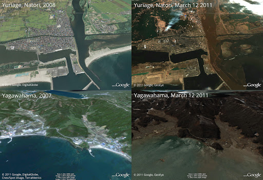
In response to the devastating earthquake and subsequent tsunami that struck Japan, we’ve worked with our satellite imagery providers to get the latest available data of the areas affected most.

To view this high-resolution imagery, courtesy of our partners at GeoEye, download this KML file and explore it in Google Earth. You can also explore the imagery with Google Maps, or have a look at this Picasa album of before-and-after shots. Here’s a sample:

Before and after the earthquake and tsunami. Above is Yuriage in Natori, below is Yagawahama; both are in Miyagi prefecture. High-resolution version of this photo.

We’re working to provide this data directly to response organizations on the ground to aid their efforts. We hope this new updated satellite imagery is valuable for them as well as everyone else following this situation to help illustrate the extent of the damage.

You can find more information regarding the disaster and resources for those in need at our Crisis Response page in English and Japanese. You can also follow @earthoutreach on Twitter to stay up to date with our mapping and imagery efforts.

Tuesday, March 1, 2011

From Bermuda to the Bahamas with the Sargasso Sea Expedition


Have you ever dreamed of setting sail across the Bermuda Triangle? Well, now you can follow the recent MBARI Sargasso Sea Expedition virtually by reading a series of posts from the cruise in Google Earth. To follow this sea expedition, download the complete log kml or visit the Earth Gallery.

MBARI (Monterey Bay Aquarium Research Institute) researchers and scientists from the University of Hawaii, University of Miami and Stanford University sailed 940 miles (1500 km) from Bermuda to the Bahamas across the North Atlantic Ocean through the Sargasso Sea. Their goal was to better understand this unique ocean habitat which is named for the free-floating brown algae Sargassum (also called “gulf weed”) and its associated community of marine life. Under the direction of Chief Scientist Ken Smith, the expedition team measured biodiversity and the impacts of climate change and carbon cycling to this ecosystem. They also learned more about deep ocean animals.

See a school of eels swarming around bait anchored to the sea floor.

The mission is the second voyage for the Schmidt Ocean Institute ship, Lone Ranger, whose Facebook page you can follow here, a former ocean tug that has been retrofitted for cutting-edge science investigations.

You can follow the MBARI Expedition Logbook to read a day by day account of the Expedition.

Monday, February 28, 2011

Pedaling to new places with Street View


Street View enables you to visit places around the world virtually, from the scenic Champs-Elysées in Paris to bustling Times Square in New York City. We’re able to collect imagery of most of these places with a car, but when we find an interesting place that a car can't reach, we get more creative.

In 2009 we introduced the Trike, a modified bicycle outfitted with Street View equipment, to visit these locations, from towering castles to picturesque gardens. The Trike team has been pedaling around the world, and today we’ve added more of these unique places to Street View in Google Maps.


With the Trike we’re able to take you inside the grounds of historic locations like the Château de Chenonceaux in Civray-de-Touraine, France.


In addition to historic sites, you can also view beautiful outdoor scenery of places like the National Botanic Gardens in Dublin.


You can now see 360-degree panoramic images of these gardens at the San Diego Art Institute, as well as several other gorgeous spots in Balboa Park in San Diego, California.


To continue exploring these and other beautiful and historic places around the world, we encourage you to visit Street View in Google Maps. If you are the owner of a private property and would to make your location available for users to explore in Street View, please visit this site to learn about our partner program.

Friday, February 25, 2011

Imagery Update - Week of February 21st

We’re just nearly two months into the new year but the Google Earth and Google Maps Imagery team’s aerial and satellite imagery updates keep coming!


Since it’s February, love is in the air and romance is on people’s minds (I mean, why stop at Valentine’s Day). And when it comes to all things amatory, no features and locations conjure up those feelings better than châteaux, castles, and royal wedding sites. Lucky for all our quixotic Earth and Maps users, we’ve got all that and more in our latest batch of published images.


Let’s start with the big one in the room. The Royal wedding isn't until April, but we’re getting ready for the big day by updating London, UK and wedding-related sites with high-resolution aerial imagery acquired this past June. In the image below, you can see the site of the royal wedding, the Collegiate Church of St Peter at Westminster, more commonly referred to as Westminster Abbey. While viewing this site in Google Earth, make sure you turn on the Photos Layer, and check out the several pano360 immersive images that dot the church confines.


Westminster Abbey, London, UK


Let’s move west a bit to the beautiful Emerald Isle. Below we’re looking at Trim Castle and adjacent grounds in the county town of Trim, in County Meath, Ireland. The castle is the remains of Ireland’s largest and dates to the 11th century. As with the Westminster Abbey location, make sure to click on the Photos layer and check out the pano360 images; the immersive images include 360° views of the castle interior.


Trim Castle, Trim, Ireland.


Lastly, let’s take a look below at some new aerial imagery of a section of the Biltmore Estate which contains the châteauesque house, the Biltmore (upper-right section of the image). The house was finished in 1895 and is located near Asheville, North Carolina. It is the largest privately-owned home in the U.S., owned continuously by members of the William Vanderbilt family.


The Biltmore Estate, Asheville, NC.


Do you have a place you love that you’d want to receive notification from us when the Earth and Maps Imagery team updates your beloved site? We’ve got just the tool: The Follow Your World application!


As always, these are but a few examples of the types of features that can be seen and discovered in our latest batch of published imagery. Happy exploring!


High Resolution Aerial Updates:

USA: Asheville, NC; Charleston, WV; Chattanooga, TN; Daytona, FL; Fayetteville, AR; Key West, FL; Perry, FL; Wachula, FL

Ireland: Kells; Navan; Omagh; Strabane; Trim

UK: Greater London; Immingham; Somerset

Switzerland: Valais


Countries/Regions receiving High Resolution Satellite Updates:

Algeria, Angola, Argentina, Australia, Austria, Bangladesh, Bolivia, Botswana, Brazil, Bulgaria, Burundi, Canada, Central African Republic, Chile, China, Colombia, Costa Rica, Cuba, Czech Republic, Côte d'Ivoire, Democratic Republic of the Congo, Dominican Republic, Ecuador, Egypt, El Salvador, Ethiopia, Faroe Islands, Finland, France, French Guiana, Germany, Greece, Guatemala, Haiti, Honduras, India, Indonesia, Iran, Ireland, Israel, Italy, Japan, Jordan, Kazakhstan, Kenya, Kuwait, Kyrgyzstan, Lebanon, Lesotho, Libya, Macedonia (FRYOM), Mexico, Morocco, Mozambique, Myanmar (Burma), Namibia, Nepal, New Zealand, Nicaragua, Niger, Nigeria, Norway, North Korea, Oman, Pakistan, Panama, Paraguay, People's Republic of the Congo, Peru, Poland, Republic of Korea, Romania, Russia, Rwanda, Saudi Arabia, Somalia, South Africa, Spain, Sri Lanka, Sudan, Suriname, Swaziland, Sweden, Switzerland, Syria, Tajikistan, Tanzania, Thailand, Togo, Trinidad and Tobago, Tunisia, Turkey, Turkmenistan, Uganda, United Arab Emirates, United Kingdom, United States, Uruguay, Uzbekistan, Venezuela, West Bank, Yemen, Zambia, Zimbabwe


These updates are now available in both Google Maps and Google Earth. To get a complete picture of where we updated imagery, download this KML for viewing in Google Earth.


Tuesday, February 22, 2011

Mission Blue: Follow an Expedition off Easter Island, Chile

Have you ever dreamed of embarking on an exciting expedition? Well, now you can follow a ship traveling the ocean in Google Earth. National Geographic and Oceana scientists in collaboration with the Chilean Navy are traveling on their next Mission Blue expedition to the remote Salas y Gomez Island. This island is 250 miles (390 km) east of Easter Island. They aim to discover what lies beneath these largely unexplored waters.

To follow along, open Google Earth and search for “Easter Island, Chile”. Look for the blue ship icon heading eastward as it travels to Salas y Gomez Island. Check back daily through March 10th to track this expedition (make sure the Places layer is turned on). The science team will share updates from the expedition as they travel east from Easter Island toward Salas y Gomez Island - including photographs, videos and links to the National Geographic News Watch blog. National Geographic and Oceana are members of Mission Blue.

We are also excited that we were able to quickly publish new imagery for the island in Google Earth and Google Maps, so that now anyone can visit Salas y Gomez virtually.

Click on the blue ship icon near Easter Island in Google Earth
to see the most recent post from the expedition.


In addition to the ship icon in Google Earth, you can also download the expedition KML or visit the Google Earth Gallery to download the file.

To bring this expedition to life for thousands of teachers and students around the globe, the National Geographic Ocean Education Program is working with Oracle® Education Foundation in the Oracle ThinkQuest online community. Educators can find lesson plans, submit questions to the research team while at sea, discuss with classrooms around the world and more. Visit the ThinkQuest website to apply to join the global community of teachers and students.

We hope you enjoy this virtual adventure at sea with the research team at Mission Blue.

Thursday, January 27, 2011

Sign up for imagery update alert


Users in the Google Earth forum often ask about the age of satellite imagery and when the content will be updated. While we aren’t able to tell you in advance when our imagery will be updated, we can now notify you after new images are added to an area that you’re interested in.

With our Follow Your World application, you can register points on the globe and we’ll send you an email update whenever the imagery is updated there.


In just three easy steps, you can add points such as your hometown, your college football stadium, or just about any place on Earth. And since Google Earth and Google Maps share the same imagery, this tool is equally handy for enthusiasts of both products. Follow Your World also provides a handy dashboard to manage your subscriptions.

Whether you’re an armchair geospatial enthusiast, or you frequently use aerial imagery from Google Earth or Google Maps in your work, we invite you to give this new app a try so you’ll be the first to know.

Posted by Jeral Poskey, Google Earth support team

Friday, January 14, 2011

45º imagery update for various U.S. cities


We’re now well into the new year, and to kick off 2011, the Geo Imagery team has just rolled out some refreshed 45° imagery for a number of places in the United States. So whether you already miss the places you may have visited over the holiday season, or you’re looking for new vacation spots to travel to this year, you can now escape the winter weather and check them out virtually from the comfort of your warm and dry home.

Did you ever want to spend an afternoon sailing on a tall ship? Well if you happen to be in Norfolk, VA you can give the American Rover Tall Ship a try.

American Rover Tall Ship, Norfolk, Virginia

If you’re not into ships, then you might be interested in the Steward Observatory in Tucson, AZ where you can check out the beautiful nighttime sky.

Steward Observatory, Tucson Arizona

If you just want to relax and have a good time, consider having a look at New Orleans. Mardi Gras is only a few months away!

Bourbon Street, New Orleans, Louisiana

And fans of art can visit the Salvador Dali Museum in St. Petersburg, Florida.

Salvador Dali’s Museum, St. Petersburg, Florida

We wish you well as you embark on your virtual trips around the U.S. viewing these and other interesting sites. And stay tuned because there’s plenty more to come in 2011!

Full list of cities that’ve been updated:
Albuquerque, NM
Contra Costa County, CA
Escondido, CA
Long Beach, CA
Norfolk, VA
New Orleans, LA
San Antonio, TX
St Petersburg, FL
Tucson, AZ
Van Nuys, CA

Posted by Wayne Thai, Geo Data Strategist

Friday, December 17, 2010

Imagery Update - Week of December 12th


‘Tis the season of giving! For those of you who’d like nothing more than to receive the gift of new places to explore on Google Earth and Maps, you’re in luck. Our imagery team’s latest update includes many places that relate metaphorically to the holiday season.

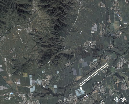
For example, it’s often at the end of the year that we remark “Out with the old, and in with the new.” That concept can also be applied to the below image that captures two military installations located North West of Beijing. You can see the fascinating juxtaposition of the modern Yongning Air Force base (bottom right) and an adjacent section of the ancient Great Wall of China (upper left quadrant) that outlines parts of the Shibapan Ling mountain range. And yes, you really can see the wall from space!

Near Beijing, China

Wouldn’t gold make a great stocking stuffer? Take a look at the below image of Jin Xixin Lake, the dammed section of the Minjiang River also known as the Gold Lake, located south of Mount Wuyi, China. In this image, you can see lots of prime locations that might make great prospecting camps. Get out your pans!

Gold (but no frankincense) near Mount Wuyi, China

Finally, although this time of year is often associated with the Christian-based holidays, when thinking about China, thoughts naturally turn to Buddhism. Just the other day on the Google campus in Mountain View, a group of Tibetan monks visited to build a Sand Mandala and lead a meditation group. In this spirit, I’ve included the below image of the first Buddhist monastery built in Tibet, the Samye Monastery.

A site of enlightenment in Tibet

The examples above only hint at the type and breadth of features that can be seen and discovered in our latest batch of published imagery. Happy exploring and happy holidays!

High resolution aerial updates:
USA: Birmingham AL, Little Rock AK, Peoria IL, Tuscaloosa AL, Worcester MA, Jerome ID, Stevenson WA, Knoxville TN, Morganton NC, and Statesville NC
Canada: Powell River, and Sunshine Coast, BC., Canmore, and Cold Lake
Netherlands: Hilversum
South Africa: Northern, Eastern, and Western Cape, and Limpopo
Sweden: Gävleborgs Län, Jönköpings Län, Uppsala Län, Västerbottens Län, and Västra Götalands Län

Countries receiving high resolution satellite updates:
Albania, Algeria, Angola, Argentina, Armenia, Australia, Austria, Azerbaijan, Bahrain, Bangladesh, Belgium, Bhutan, Bolivia, Bosnia and Herzegovina, Botswana, Brazil, British Virgin Islands, Brunei Darussalam, Bulgaria, Burkina Faso, Cambodia, Cameroon, Canada, Chad, Chile, China, Colombia, Costa Rica, Croatia, Cuba, Democratic People's Republic of Korea, Democratic Republic of the Congo, Denmark, Dominican Republic, Ecuador, El Salvador, Estonia, Ethiopia, Finland, France, Georgia, Germany, Greece, Guatemala, Haiti, Honduras, Hungary, India, Indonesia, Iran, Ireland, Israel, Italy, Japan, Jordan, Kazakhstan, Kenya, Kuwait, Kyrgyzstan, Laos, Latvia, Lesotho, Liberia, Libya, Lithuania, Luxembourg, Madagascar, Malawi, Malaysia, Mali, Mauritania, Mexico, Mongolia, Montenegro, Morocco, Mozambique, Myanmar, Namibia, Nepal, Netherlands, New Caledonia, New Zealand, Nigeria, Norway, Oman, Pakistan, Panama, Papua New Guinea, Paraguay, Peru, Philippines, Poland, Portugal, Puerto Rico, Republic of Korea, Romania, Russia, Samoa, Saudi Arabia, Senegal, Serbia, Slovakia, Slovenia, Solomon Islands, South Africa, Spain, Sri Lanka, Sudan, Sweden, Switzerland, Syria, Taiwan, Tajikistan, Tanzania, Thailand, Turkey, Turkmenistan, Uganda, Ukraine, United Arab Emirates, United Kingdom, United States, Uruguay, Uzbekistan, Venezuela, Vietnam, Virgin Islands, West Bank, Yemen, Zambia, Zimbabwe

These updates are currently only available in Google Earth, but they'll also be in Google Maps soon. To get a complete picture of where we updated imagery, download this KML for viewing in Google Earth.

Posted by Eric Kolb, Geo Data Strategist

Under the hood of Google Maps 5.0 for Android

[Cross-posted from the Official Google Blog]

Yesterday we introduced Google Maps 5.0 for Android with two significant new features: 3D interaction and offline reliability. In order to create these features, we rebuilt Maps using vector graphics to dynamically draw the map as you use it. Building a vector graphics engine capable of achieving the visual quality and performance level you expect from Google Maps was a major technical challenge and enables all sorts of future possibilities. So we wanted to give you a closer look under the hood at the technology driving the next generation of mobile maps.

Vector graphics
Before diving into how Maps uses vector graphics, it may be helpful to understand how maps were created before. Previously, Google Maps downloaded the map as sets of individual 256x256 pixel “image tiles.” Each pre-rendered image tile was downloaded with its own section of map imagery, roads, labels and other features baked right in. Google Maps would download each tile as you needed it and then stitch sets together to form the map you see. It takes more than 360 billion tiles to cover the whole world at 20 zoom levels!

Now, we use vector graphics to dynamically draw the map. Maps will download “vector tiles” that describe the underlying geometry of the map. You can think of them as the blueprints needed to draw a map, instead of static map images. Because you only need to download the blueprints, the amount of data needed to draw maps from vector tiles is drastically less than when downloading pre-rendered image tiles. Google Maps isn’t the first mobile app to use vector graphics—in fact, Google Earth and our Navigation (Beta) feature do already. But a combination of modern device hardware and innovative engineering allow us to stream vector tiles efficiently and render them smoothly, while maintaining the speed and readability we require in Google Maps. Just try it out and see for yourself!

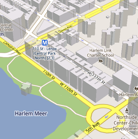
See the difference between image tiles (left) and vector tiles (right) tilted to show 3D buildings.

One map, many perspectives
Using vector tiles instead of image tiles gives Maps the flexibility to re-draw the same map from different perspectives using the same set of data. Zooming is one example of this at work. If you magnify an map image tile by 2x, lines such as roads and text would get twice as wide and appear blurry. As a result, we had to constrain Maps to 20 fixed “zoom levels,” each one twice as close as the last. Every time you zoomed in further, you’d need to download a completely new set of image tiles. It took time to load new data over a mobile data connection, and would fail when you lost your connection in a subway or large building.

Compared to image tiles (left), vector tiles (right) keep lines and labels crisp as you zoom.

With vector graphics, you no longer need to “round” to the nearest zoom level and then download all the tiles for that level. One vector tile has the underlying vector data (or blueprints) to draw the map at many different levels of scale. So when you zoom, the map stops when your fingers stop, and roads and labels always stay crisp. This same technique powers the new 3D map interactions: tilt, rotate and compass mode. Just like with zooming, Maps uses the same vector data to draw the map from any angle or direction as you tilt or rotate.

We can also display entirely new levels of detail that weren’t possible with flat image tiles. For example, in the 100+ cities where we have 3D building data, each building is drawn in 3D using a polygonal building footprint and heights for different parts of the building. And with tilt and rotate, you can see them from a variety of different angles.

Reading the map
Just like other map features, labels are dynamically drawn so they continue to face you and stay legible if you rotate the rest of the map or use compass mode. Maps also “chooses” the best labels to show you based on several factors. You’ll notice labels fade in and out as you interact with the map so that the most useful ones appear and the map never gets too cluttered.

See the difference between rotating maps with static labels (left) and dynamic labels (right).

Vector graphics also allow us to draw additional data on the map more clearly. For example, traffic or transit lines no longer block the labels beneath them. We can also draw the same map in different styles—like “satellite view” where the roads are translucent over aerial imagery, or Navigation’s “night mode” where a darker palette helps your eyes adjust quickly in the lower light.

Previously, map features like labels and traffic could conflict (left) instead of blend seamlessly (right).

Offline reliability
Vector graphics also enable another significant new feature: the ability to continue viewing maps even when you have poor—or no—network connections. Because each vector tile works across multiple zoom levels, it requires more than 100 times less data to view maps across all zoom levels than before, allowing Maps to cache much larger areas of the map on your device.

With this first version, Maps proactively caches map data for the places you use Maps the most—where you’re actively using it as well as places for which you search or get directions. Then when you’re plugged in and connected over WiFi, caching happens automatically. Near your frequent places, you’ll get detailed vector tiles for city-sized regions so you can see every road labeled. Further away, you’ll have less detail but will typically have towns and highways labeled for miles. We’re continuing to work on these algorithms, so you’ll see improvements over time.

Offline rerouting
With Google Maps Navigation (Beta), you’ll also see the benefits of additional caching with offline rerouting. This feature is only possible because Navigation caches not only map data but also data like turn restrictions for the areas surrounding your route. You’ll still need to be connected when you first start a trip to download and cache your route. But this way, even if you take a wrong turn after losing your connection, Navigation can use the cached data to get you back on your way. We will be rolling this feature out gradually over the next few weeks.

This is just the start, and we’re really excited about all the possible ways to use vector graphics technology for the next generation of Google Maps. So please stay tuned!

Thursday, December 16, 2010

The next generation of mobile maps

[Cross-posted from the Official Google Blog and Google Mobile Blog]

I’m excited to announce Google Maps 5.0 for Android, with two significant new features: 3D interaction and offline reliability.

We launched Google Maps for mobile a little more than five years ago. Since then, we’ve added dozens of features, and we’ve grown from a few thousand to more than 100 million users. Still, a couple of things have remained the same: a flat, north-up map and the need for a strong Internet connection. Today, we’re changing that for the first time.

Tilt while zoomed in (left) or use compass mode (right) to orient yourself with 3D buildings.

Explore maps in 3D
Until now, Google Maps has always downloaded the map as a set of small, square images that we stitch together to form the map you see. (You’ve probably seen those gray squares getting filled in, block-by-block, as the images load over the network.) Starting today, we’ll use vector graphics to dynamically draw the map on your device as you use it, allowing you to interact with it in new ways:
  • Tilting: Drag down with two fingers to tilt the map. Tilt while zoomed in on one of the 100+ cities around the world with 3D buildings to see a skyline spring to life.
  • Rotating: Twist with two fingers to rotate the map. After tilting to see 3D buildings, rotate around them to gain a new perspective from any direction.
  • Smooth zooming: Slide two fingers together or apart, and see the map and labels continuously scale to any zoom level, stopping when your fingers stop.
  • Compass mode: Center the map on your location, and then tap the compass button in the top right corner. The map will flip into 3D mode and start rotating to match your perspective, while still keeping all the labels upright and readable.
I found 3D buildings especially useful on a recent trip to New York. From my hotel to the Google office in Chelsea and bars on the Lower East Side, this richer representation of the real world made the map much more helpful. And whenever I walked out of a building or subway station, I used compass mode to get myself quickly oriented and on my way. Check out the video below to see tilt, rotation, zoom and compass mode in action, or see more pictures.


Offline reliability
Google Maps has always been, and continues to be, a fundamentally Internet-connected experience, meaning you always get the freshest map and place data, search and voice search, live traffic conditions, satellite and Street View imagery, and much more. Still, we understand that mobile Internet connections aren’t 100% reliable. So today we’re happy to take the first steps toward greater offline reliability, so you can find your way even if you lose your connection.

In the past, you’ve probably had frustrating moments when you get stranded without a map, whether ducking into the subway, sitting at the back of a restaurant or traveling anywhere with a flaky Internet connection. But dynamically drawing maps requires 100 times less data to get maps across all zoom levels, so now we’re able to proactively cache (or store) large areas on your device based on where you use Maps the most. This way, you can rely on having fast, robust maps available to you where you’re most likely to need them.

For example, I live in San Francisco and work in Mountain View, so Maps makes sure I can always pull up detailed street maps of each city and area maps for the whole San Francisco Bay Area. When I do have an Internet connection, I still get live traffic, imagery, richer map details and all the other features I’m used to with Google Maps.

Rather than having a static set of maps when installed, Maps will automatically start caching the areas you visit the most when your device is plugged in and connected to WiFi (e.g., the nightly charge). We’re already hard at work improving the algorithms and technology behind these features, so over time you can expect to see maps work better in more offline situations.

Offline rerouting
If you’re one of the more than 10 million people relying on Google Maps Navigation (Beta), our free turn-by-turn GPS navigation feature, losing your Internet connection can be particularly painful. (This happened to me on a recent ski trip to Tahoe, and I was left trying to manually find my way back to my route.) So we’re also introducing offline rerouting. You’ll still need a connection to start a route, but if you miss a turn along the way, we’ll quickly get you back on track, even if you don’t have an Internet connection. We’ll be rolling this feature out gradually over the next few weeks.

Google Maps Navigation now automatically reroutes you, even if you lose your connection.

These new features are just the first steps in maximizing dynamic map drawing technology to create a faster, more interactive experience where efficiency really matters: mobile devices. For example, we estimate that viewing maps now requires almost 70% less mobile network data overall than before. We can’t wait to take the next steps in making Google Maps faster, more reliable and even more useful no matter where you take it.

Get Google Maps for mobile 5.0 by searching for Google Maps in Android Market (or tap on this link if you’re on your phone). Android 1.6+ devices can get Maps 5.0, but 3D and offline features require Android 2.0+, and some features may not be supported for all devices or countries.

So try it out. Wander around in compass mode, explore 3D buildings—even dare to open Maps on the subway! I hope you enjoy all the new features as much as we do.