Wednesday, October 31, 2007
More languages in 3D Warehouse
If you've had a chance to stop by the Google SketchUp Blog today, you most likely saw my post heralding the release of 3D Warehouse in eight new languages. Now Portuguese, Dutch, Russian, Polish, Korean, Arabic, Czech, and Traditional Chinese join our list of available translations. Already included are English, French, German, Italian, Japanese and Spanish.
We're hoping the release of Google 3D Warehouse in these additional languages will encourage folks across the globe to contribute sketches. I'm certainly looking forward to seeing all of your work!
For more information about getting started, take a look at this 3D Warehouse overview.
Earthquake mapping
I was working kind of late last night, and around 8:04 pm, I felt the floor underneath my desk shake and move. For a second I thought the Google Halloween party was getting wild, but then I realized I was experiencing my first earthquake!
Equipped with my mapping skills, I went to explore what exactly happened. I found some cool things about the earthquake by using Google Maps, and I thought I would pass this info along to you:
Where did it happen?
A search through user-generated content on Google Maps quickly provided the answer. Many of our My Maps users created maps pointing to the center of the earthquake minutes after it happened. To access this data, search for "Alum Rock Earthquake" scroll down the search results, and click on "see more community maps."
Add earthquakes to your map:
I didn't think our post from the folks at the U.S. Geological Survey would come in handy quite so soon! Their Earthquake Mapplet shows all of the earthquakes that have taken place throughout the world in the last week. Click on the "Save to My Maps" link to customize your My Maps tab and include earthquake data.
Explore earthquakes in Google Earth:
A 3D view of earthquakes is very useful to understand their impact. If you have Google Earth installed, check out this Earthquake KML from USGS. Fly to San Jose, click on the big orange circle, and choose "View ShakeMap" link to see the full impact of the earthquake.
Map of the day: Halloween edition
Happy Halloween from the Google Maps team! If you're looking for local costume parties or haunted houses, here are some Halloween event maps for different cities in the U.S.:
Portland corn mazes and pumpkin patches - A guide to Portland, Oregon metro-area corn mazes, pumpkin patches and fall harvest events, created by the Oregonian News.
Chicago's Haunted Houses - Best places for a scare in the Windy City.
Halloween Happenings in Detroit - Fun events for the entire family throughout the month of October, created by MyFoxDetroit.com.
Where the Scares Are, LA 2007 - A map to month-long haunted attractions throughout greater Los Angeles, created by CreepyLA.com.
OC Halloween Events - The top Halloween attractions, events, and entertainment in Orange County, including Disneyland, Knott’s Scary Farm, haunted houses, Halloween balls and more.
Halloween in Tampa Bay - All of Tampa Bay's spooky events.
Friday, October 26, 2007
Weekly Google Code Roundup: Leopard day, JavaScript fun, and the open source world.
It's Leopard day. I am really excited to get home to install the new version of OS X. It isn't actually the new operating system itself that excites me, it is the new applications that I know have been waiting for this release to be able to see the light of day. Our own Google Mac team has announced an update for Leopard, so update Google Desktop before you change your strips for spots. When you setup the new Mail.app, consider enabling IMAP in Gmail and using both (I have been looking forward to IMAP support for a long time)!
I was really excited to see our Blogger GData JavaScript client library release. I am particularly proud of the examples that came along with the release as they really show you some of our ideas and give you good starting points for your own secure mashups.
If you want to test GData endpoints, there is help for doing some testing with cURL which we documented for you.
We got to hear to some of the teams too. Bruce Johnson and Joel Webber, members of the Google Web Toolkit team, had a nice interview with Pearson before the upcoming conference on GWT.
Paul McDonald and Rich Burdon of the Google Mashup Editor Team also discussed the nuances of the GME product and where it is heading.
In the Google Maps world Pamela played with clickable Polygons and used the ability to play a game. Also, if you are a Flash-y kind of guy, you can do more with KML and Flash.
We hosted a lot of open source meetings such as:
For those that like to search across open source code, we have a new ability to tell us more about your code via the integration of Google Code Search and Sitemaps.
Fancy some video? We had some great tech talks on campus including:
- Randall Schwartz on Git
- An internal look at VMware Fusion
- Internet Security Keynote Google VP Vint Cerf
As always, check out the latest tech talks, subscribe to the Google Developer Podcast and visit the Google Code YouTube channel.
I am now heading out to get Leopard roaring, but a couple of final points. The new Google Finance Gadgets are interesting, and take a look at how our developer team lives in a Mario World.
Thursday, October 25, 2007
Podcast with Bruce Johnson and Joel Webber
Last week the folks at Pearson Education sat down with Bruce Johnson and Joel Webber to discuss the creation of Google Web Toolkit and Pearson's December conference Voices that Matter: Google Web Toolkit. Listen to the podcasts to hear Bruce and Joel explain the history of GWT and the challenges of building a cross-browser Java-to-Javascript compiler. They also talk about the sessions that they are most looking forward to attending at the conference, and their upcoming book on GWT. Thanks to Bruce and Joel for sharing their thoughts and to Barbara and Greg at Pearson for putting this together.
Registration for the Pearson conference is still open, but be sure to register before October 27th (this Saturday) to receive the early bird pricing discount. You can review the complete list of sessions and speakers on the conference website.
Master layer for Southern California fires imagery
We have created a master layer in Google Earth that includes all of the imagery of the affected areas that we've published so far. The new layer includes imagery from MODIS (from 10/24) as well as updated fire perimeters from the San Diego EOC. And we'll incorporate new imagery as it becomes available.
Be sure to save the KML file to "My Places" by right-clicking and choosing "Save to My Places." To get the latest updates, right-click on the KML file in "My Places" and then choose "Refresh."
Update (4:15, 10/26): We've incorporated infrared SPOT-5 satellite imagery from Spot Image Corporation and new data from NASA and the San Diego Emergency Operations Center into the master layer.
Image (c) CNES 2007 / SPOT Image Corporation
Wednesday, October 24, 2007
Google Hosts CIFS Workshop
Around sixty developers from over twenty different companies converged on Google's Mountain View Campus at the end of September to sample the free food. Oh yes, and also to test their implementations of the CIFS network protocol for interoperability.
CIFS, the Common Internet File System (that's Windows Networking to you and me), is the file sharing protocol build into all Windows versions, and also MacOS X, Linux, HPUX and now Solaris clients. Samba is the best known Free Software implementation of CIFS, and most of the Samba Team were there to help improve Samba3 and Samba4's interoperability along with the other CIFS vendors.
Over the three days much code was written, much beer was drunk, and the air was turned blue with cursing when bugs were found! As the Samba Team were mentoring several Google Summer of CodeTM students, we also got to record a podcast about our experiences participating in the program over the past three years.
Thanks to Google for hosting the event and setting up the gigabit networking required. The endless coffee supply was also essential when dealing with network protocol problems.
The best summary of the success of our testing occurred on the final day of the event, when a sad and frustrated CIFS client programmer wrote the following on our testing notes whiteboard:
"the server *hates* me :-) :-)"
It was great to see everyone coming together, even people from competing companies, to help fix problems with everyone's implementations of CIFS. Look for the resulting improvements in new versions of products and future releases of Samba.
Southern California fire imagery
As the fires in Southern California continue to spread, our data providers have gathered updated imagery of the affected areas. We are making this imagery taken on October 22nd available as a Google Earth overlay, and will continue to update the imagery as it becomes available. Our thoughts are with the communities displaced by this tragedy.
Thanks to DigitalGlobe for their fast work.
Image (c) 2007 DigitalGlobe
Update (9:02 PM): Thanks to NASA and the US Forest Service, overlays of the fire perimeters and thermal infrared imagery, both captured today, are now viewable in Google Earth.
Update (12:40 AM): The San Diego Regional Emergency Operations Center has provided us with valuable information including fire perimeters, mandatory evacuation areas and re-opened areas.
If you have not yet downloaded Google Earth, you can do so here.
Where in the world is ... (bonus edition -- Answers)
Great job, everyone! I love following your collective blog entries tracking the updates, especially the ones that find updated imagery totally unrelated to the hints I gave.
Answers:
1) U.S. Route 91 turns into a much more famous stretch of road when it crosses into this town.
-- Las Vegas (The Las Vegas Strip)
2) Every year, this city plays host to the U.K.'s largest outdoor (temporary) ice rink.
-- Leeds, England (The Ice Cube)
3) Paradise: In this town you can surf or visit the world's most delicious book store, located in
an old Twinkie factory (with plenty of aging filling still in the pipes).
-- Cleveland (Anyone who watches "Anthony Bourdain: No Reservations" should have gotten that one right!)
4) The original name of this city was Terminus.
-- Atlanta, Georgia
5) The world's northernmost opera house is located in this town.
-- Umeå, Sweden
6) This major U.S. city is actually north of Canada.
-- Detroit, Michigan
7) A popular children's game show that promoted geographic knowledge was produced out of
this city.
-- Pittsburgh (Where in the World is Carmen Sandiego?)
8) Don't let the name fool you -- this lake actually fills a 4,000ft deep caldera.
-- Crater Lake, Oregon
9) You can tour the Royal Navy's first iron-hulled, armor-plated warship in this town.
-- Portsmouth, England (HMS Warrior)
10) The historic fort in this city was restored based on an 1847 map published in Darmstadt,
Germany.
-- Sacramento (Sutter's Fort)
11) As Halloween approaches, one might be interested in viewing the 'Ghost Capital of Britain.'
-- Derby, England
12) Now part of Germany, this city was once the capital of the Hanseatic League.
-- Luebeck, Germany
13) President Lincoln attended the dedication ceremony of the Soldier's National Cemetery in
this town.
-- Gettysburg, PA (President Lincoln gave the Gettysburg Address at this dedication ceremony.)
Here's a more complete list of imagery updates in this data push:
New high resolution:
Western Mississippi, Much of Pennsylvania, Yakima County (WA),
Benton County (WA), Whistler (BC), San Jose (CA), Imperial County (CA),
Steamboat Springs (CO), Calhoun County (FL), Adams County (IL),
Washtenaw County (MI), Chemung County (NY), Cortland County (NY),
Castilla (Colombia)
Europe, Middle East & Africa:
- France: French Riviera, Avignon
- UK: Exeter, Brighton, Crawley, Essex, Colchester, Chelmsford,
Swindon, Cheltenham, Ipswich, Norwich, Peterborough, Leicester,
Chesterfield
- Germany: Freiburg, Stuttgart, Waiblingen, Remseck, Kornwestheim,
Ludwigsburg, Saarbruecken, Chemnitz, Erfurt, Ratigen,
Munster, Hamburg, Luebeck
Umea (Sweden)
Borger-Odoorn (The Netherlands)
2.5m imagery for the entire countries of: Tunisia, UAE, Jordan, Syria, Lebanon, and Israel.
Updated Imagery:
Americas: Las Vegas (NV), San Francisco Bay Area (East Bay & North Bay),
Sacramento (CA), Victoria (BC), Salt Lake City (UT), Provo (UT), Edmonton (Alberta),
Atlanta (GA), Northern St Louis (MO), Detroit (MI), Cleveland (OH), Pittsburgh (PA),
Boston (MA), Montreal (Quebec), Guadalajara (MX), Buenos Aires (Argentina),
Belo Horizonte (Brazil), Fortaleza (Brazil), Montevideo (Uruguay)
Europe, Middle East & Africa:
- UK: Plymouth, Torquay, Bournemouth, Southampton, Portsmouth, Gillingham
Southend, Basildon, Berkshire, Reading, Milton Keynes, Newport, Cardiff,
Swansea, Cambridge, Norfolk, Derby, Halifax, Leeds, Darlington, Dundee,
Belfast
Warsaw (Poland), Stockholm (Sweden), Lippstadt (Germany), Magdeburg (Germany),
Paderborn (Germany), Rostock (Germany), Boeblingen (Germany), Casablanca (Morocco),
Bamako (Mali), Windhoek (Namibia), Ankara (Turkey), Kano (Nigeria)
Asia & Oceania: Novosibirsk (Russia), Tashkent (Uzbekistan), Ahmendabad (India),
Pune (India), Bangalore (India), Hyderabad (India), Perth (Australia), Brisbane (Australia)
Ulan Bator (Mongolia),
Updated Terrain:
Canada (20m and 90m) and Niagara Falls
Tuesday, October 23, 2007
Updates from the I Free Software Forum
I recently traveled to the I Free Software Forum in Lisbon, Portugal, where I gave two talks. The first was on load balancing and the second focused on "Google e o Software Livre" (Google and Free Software). The main organizer of the conference was Ralf Braga, an old friend of mine from Brazil, who moved to Lisbon few months ago.
Both of the talks were well attended, which was great. During my load balancing talk, I covered things I found out while testing Linux Virtual Server and HAProxy, two open source software load balancing solutions. I explained a bit about the basics of load balancing, and then the pros and cons of each approach.
Lisbon is a very beautiful city. Everyone was chatting about the amazing growth of conferences about "Software Livre" in that country. There will be a total of 6 conferences about open source software around Portugal in just the next few months.
There were around of 200 people attending two simultaneous rooms of talks over two days, and most attendees were university students. One of the sponsors prepared the table for their booth in the same shape as the Ubuntu logo. Really cool. They also had Ubuntu pillows. Do we have Google Code pillows? We should. :)
The organizers are planning the second edition of the conference for next year already. I proposed to the participants that each one of them brings at least one friend who has never been to an free software conference before with them when they return. I know I'm already looking forward to going in 2008!
(The I Free Software Forum site is in Portugese. You can read an English translation.)
KDE 4.0 Release Party at Google HQ
When we met Sebas at the Ubuntu Developer Summit last November, he thought the digs were pretty cool and he asked if Google would be willing to host a release party for KDE's upcoming 4.0 launch. Since Sebas seemed like such a nice chap and we love hosting open sourcerers, we said "Hey, why not?"
While the KDE development team has been hard at work preparing Betas, we've been collaborating with the project's outreach team on details for the release party. The release party, along with typical conference activities like presentations and BoFs, will be rockin' at Google Corporate Headquarters January 17-19, 2008.
If you're looking for more information on the event, check out Troy Unrau's blog. Rumor has it that that KDE e.V., the non-profit organization behind the KDE project, will even fly one lucky KDE community member out for the release party.
We hope to see you there!
Where in the world is ... (bonus edition)
Surprise! I bet you weren't expecting another imagery update from the Google Earth/Maps team so quickly. ;-)
I'm very happy to announce that, today, we've published a large amount of new high-res imagery around the world. While in the previous post I spoke of 60cm imagery, this release has mostly aerial (higher-resolution) data, as well as some medium-resolution imagery for large swaths of land. Some of you were able to solve the last quiz within a few hours of posting it, so I'm going to throw in some more challenging clues this time around.
1) U.S. Route 91 turns into a much more famous stretch of road when it crosses into this town.
2) Every year, this city plays host to the U.K.'s largest outdoor (temporary) ice rink.
3) Paradise: In this town you can surf or visit the world's most delicious book store, located in
an old Twinkie factory (with plenty of aging filling still in the pipes).
4) The original name of this city was Terminus.
5) The world's northernmost opera house is located in this town.
6) This major U.S. city is actually north of Canada.
7) A popular children's game show that promoted geographic knowledge was produced out of
this city.
8) Don't let the name fool you -- this lake actually fills a 4,000ft deep caldera.
9) You can tour the Royal Navy's first iron-hulled, armor-plated warship in this town.
10) The historic fort in this city was restored based on an 1847 map published in Darmstadt,
Germany.
11) As Halloween approaches, one might be interested in viewing the 'Ghost Capital of Britain.'
12) Now part of Germany, this city was once the capital of the Hanseatic League.
13) President Lincoln attended the dedication ceremony of the Soldier's National Cemetery in
this town.
I'll post the answers to these clues in a few days. Good luck, everyone!
As a teaser, here's what our new Niagara Falls image looks like...
Monday, October 22, 2007
San Diego Fire Map
For those of you affected by the two wildfires in San Diego County, KPBS Online created a fire map that includes up-to-date news on the spread of the fire and shows the location of evacuated areas, Red Cross evacuation centers, and closed highways. They are also providing live radio coverage of the fire.
The Los Angeles Times is also tracking fires across Southern California in a map, found here.
Update: We've posted an updated list of fire maps and other information on the Official Google Blog.
Friday, October 19, 2007
Blogger GData JavaScript client library released with offline Blogger client example
Near the end of September we announced the release of a new GData JavaScript client library that allowed you to do full read-write access to Google Calendar from JavaScript.
We now have another service for you to have at. A GData JavaScript client for Blogger has been released, which means that you can now do richer mashups with blog content.
We sat down with Ryan Boyd and Pamela Fox to discuss the release and delved into some of the sample applications that have already been written. They include:
- A tool that takes your upcoming Calendar entries and creates blog posts of the events
- A code snippet that you can add to your website that enables visitors to your site to click on a link to comment on your content on their own blog
- Code that allows you to search blogs on various topics, find entries, and again allow users to comment on their own blog
Pamela also worked on Blog.gears, a Blogger client that works offline using Google Gears. She took some time to take a peak at the architecture behind the application, and then walked us through the application itself.
If you have ever wished that you could do writable Blogger mashups without the need of proxy code on your own server, take a peak at the new client library, and listen in:
Recap of Google's International Cleanup Weekend
Well, the numbers are officially in for International Cleanup Weekend. When the dust settled, we looked at the map and found that cleanups were planned in 35 countries, involving over 3,000 participants in almost 300 cleanup projects. Now that's a lot of trash and a lot of cleaning up.
When we started crafting our plans, we expected to see cleanups in the 15 countries where the 'My Maps' tab in Google Maps is available. We were pleased -- and surprised -- to find cleanups in many more countries than that, and even one that took place underwater. Our thanks go out to the 41 environmental organizations around the world that joined the cause, and to the United Nations Environment Programme.
And our biggest thank you goes out to everyone who participated. We know that picking up trash isn't the most exciting thing to do with your weekend, but you can give yourself a pat on the back for helping to make a difference. Of course, we also hope that your efforts won't end with this project. Whether or not you organized a cleanup last weekend, we hope you'll consider making a map for another project that will make a difference close to home. Remember, changing the world starts with you.
Take a peek at some of our favorite cleanup projects from the weekend, all created within Google Maps:
An interview with Paul McDonald and Rich Burdon of the Google Mashup Editor Team
We had the pleasure of sitting down with two of the Google Mashup Editor team to discuss the product and how developers can use it to build mashups in short order.
We start out by discussing what the product actually is. The term "mashup" is a very overloaded term out there, so a mashup editor could do a number of things. What are the pieces? How does it compare to other tools like Yahoo! Pipes (complementary!)? What are the user and global feeds?
We then delve into practices for building your mashups, and discuss good examples that are out there. We finish up discussing areas that the team would like to delve into as the product evolves.
So, take some time to download the episode directly, or subscribe to the show (click here for iTunes one-click subscribe).
Thanks to Paul and Rich for taking the time to chat with us.
Livin' in a Mario World
I think we all remember the 8-bit awesome that was classic Super Mario Brothers. Most of us in Developer Ops have spent many hours immersed in the pixelated world of question marks, mushrooms, coins, and Koopas. So, when the cube decorating contest (the theme was 'Games') was announced, the course of action seemed obvious.
I recruited a few lieutenants and we had some brainstorming sessions -- complete with design docs sketched out on a whiteboard.
There would be two main areas - the classic Level 1 terrain and an underwater level. We took on this task with typical Google vigor -- 15 yards of blue cloth, 5 rolls of saran wrap, 10 pieces of posterboard, foam, lots of color printer toner, and a few afterwork hours/weekends later, here are some of the results.
They say that a good work environment increases productivity. Where better to seek inspiration than the hardest working plumber ever?
Living the dream.
Stephanie Liu
On behalf of the Developer Operations team
P.S. In case you were wondering, we came in 2nd to Analytics (their theme was Jumanji). They had a motion sensor box that triggered a tiger roar when you walked by though. It was pretty cool.
Thursday, October 18, 2007
Tell us about the code on your site with Code Search Sitemaps
By Bram Moolenaar, Software Engineer
We've heard from a number of site owners who want to make sure their public source code is searchable via Google Code Search. To help with that, we extended the Sitemap Protocol to support code files. This makes it possible to specify all the code files on your site, as well as the programming language and software license for each file.
To get started, check out the new Code Search tags for Sitemaps. For complete software packages that are archives (.tar, .tar.gz, .tar.bz2, or .zip), you can create a packagemap file to describe all the individual code files in each package. For example:
<urlset xmlns="http://www.sitemaps.org/schemas/sitemap/0.9"
xmlns:codesearch="http://www.google.com/codesearch/schemas/sitemap/1.0">
<url>
<loc>http://example.com/download/myfile.c</loc>
<codesearch:codesearch>
<codesearch:filetype>C</codesearch:filetype>
<codesearch:license>LGPL</codesearch:license>
</codesearch:codesearch>
</url>
<url>
<loc>http://example.com/download/myproject.tgz</loc>
<codesearch:codesearch>
<codesearch:filetype>archive</codesearch:filetype>
<codesearch:license>Apache</codesearch:license>
<codesearch:packagemap>packagemap.xml</codesearch:packagemap>
</codesearch:codesearch>
</url>
</urlset>
Once you've created your Sitemap, post it to a public URL on your site and then be sure to submit it through Google Webmaster Tools.
We hope this effort will help make even more code accessible and useful for developers. Let us know what you think. There's still a lot more code out there, so we'll keep working on improving Google Code Search as a tool for finding it.
Wednesday, October 17, 2007
Joomla!Day USA East at Google
Last weekend, Google hosted the first Joomla!Day to be held in New York City. We had around 80 users and developers join us to discuss everything from the GPL to cool new features added to the project's latest release candidate. We had a mix of scheduled talks and unconference-styl breakout sessions, plus a cool hacking lounge open throughout the day. We concluded with a review and collaborative feedback session on the Joomla! sites created by several of the conference attendees.
If you'd like to hear a bit more about the event and some of the co-conspirators who made our day a success, check out the wrap up post by Louis Landry, Joomla! Project Manager and one of their developers.
Many thanks to all of our guests for joining us and sharing their time and collective creativity!
Put yourself on the map
Who knows your neighborhood better than you? That's why we've been releasing features that let you add your own content to Google Maps. For example, you can use our map-creation tools to make maps of recommended places to visit or leave ratings and reviews for your favorite restaurants. Your maps and reviews will be seen by the millions of people who use Google Maps every day.
Starting today, you can find out more information about the people behind these contributions through their user profile pages. For example, if you stumble upon a cool map of a bike route, you can hover over the creator's nickname and see a snippet of information about them.
If you click on their name, you'll see their profile page, which includes links to all the content that they have authored on Google Maps, including the maps they've created and the reviews they've written. If you liked the bike route you were looking at, chances are they mapped out some other cool bike routes as well.
To create your own profile, simply sign in to Google Maps and click on the My Profile link in upper right hand corner.
If we haven't convinced you yet, check out this cool video we put together outlining how to work on your own personal profile today!
Tuesday, October 16, 2007
Raising the limits for KML on Maps
There's so much of the world to see, and sometimes it just doesn't all fit onto a map at once. Previously, people have written custom Mapplets or Maps API pages to visualize their dense geographic databases, and that's still what we'd recommend if you are a web developer and want the full interactivity of JavaScript. If you don't need that functionality, however, Google Maps now offers a better view of KML files of similar density and richness, especially when they contain <NetworkLink>s whose servers' results are tailored to the part of the world that is in view. For example:
- The photos from our friends at Panoramio can be viewed via the same KML file you could use in Google Earth, or
- you can watch the Wikipedia articles added to Placeopedia, or similarly see the areas noted in Wikimapia, or
- browse the volcanoes of the world, courtesy of the Smithsonian Institution, or
- pick from Travel and Leisure's top 500 hotels of the world.
If you like these examples, try the 'Save to My Maps' link, just under the 'My Maps' tab, to keep them around so you can do things like view Panoramio photos while searching for hotels near a potential holiday destination.
Map of the day: Celeb spotting in New York City
I know this isn't the kind of star gazing we usually report on around here, but for those of you who follow celebrity gossip, here's your chance to spot celebrities in real life. Top 50 Places to See Celebrities in NYC is a user-created map that lists all the hottest restaurants, clubs, bars and hotels in New York where you're most likely to run into celebrities like Nicole Richie, Jay-Z, J.Lo, Paris Hilton and Bruce Willis. For example, the Tribeca Grill is owned by Robert DeNiro and is frequented by his actor pals like James Gandolfini. Meg Ryan gets her famous shag haircut at the Sally Hershberger salon. And I think I once saw Julianne Moore at French bistro Pastis, which is right near the Google office.
For more examples of celebrity sightings on Google Maps, try searching for [celebrity sightings in New York]. Click on 'See community maps' to see more user-created maps.
Monday, October 15, 2007
Sigurd Magnusson of SilverStripe on open source and the Summer of Code
Sigurd Magnusson, co-founder of the SilverStripe open source CMS platform, was in town for the mentor summit that wrapped up the Summer of Code.
We used that opportunity to grab him, put him in a Tiki hut, and chat with him about SilverStripe. We discuss life as an open source company, and the experience and advice based on having ten students enrolled in the summer of code program.
Thanks to Ohloh we have statistics on the code produced by the students. Obviously, the lines of code metric is purely quantitative and doesn't show the actual work involved, but it is great to see how these students have produced:
In the chat below you will hear about some of the really cool additions that SilverStripe has in its trunk thanks to the students.
International Cleaner-Uppers: Show us your rubbish!
In keeping with the environmental theme of the day, we're happy to announce that the first International Cleanup Weekend was a success! If you participated, please remember to add photos and videos to your cleanup map. Don't forget to check back on Thursday for a full summary of the weekend's achievements.
Update: The maps have already started rolling in. Check out this great one created by a Boulder-based Googler for inspiration.
Bioneers and Google Earth
What do you get when you cross a conservation biologist with an engineer? A "bioneer," of course. The Bioneers integrate ideas and practices from many disciplines and cultures, with the broad goal of restoring the Earth and its environment. Each year since 1990, the Bioneers have brought together leading thinkers (and doers) at their annual conference to exchange ideas, foster connections and build new skills.
In honor of Blog Action Day, we're excited to announce that, this year, the Bioneers have invited the Google Earth Outreach team to lead a series of demonstrations and hands-on tutorials on Google Earth/Maps. We will be helping them understand how to visualize their important ideas and projects in the context of the real Earth, to collaborate more effectively with one another and to communicate more powerfully with citizens and decision-makers around the world.
For those of you out there who also want to "save the planet," our Google Earth Outreach site offers online resources to help you get started -- such as video tutorials, case studies, and a showcase gallery of great public-benefit Google Earth projects. Our team also staffs a help forum to answer your technical questions.
The goal of Bioneers is ambitious -- going beyond "sustainability" to the more challenging task of actual restoration of the Earth. As they comment:
Update: Our presentation schedule at the conference is now online. Join us!
Friday, October 12, 2007
Zoom in on Google Maps
Remember what would happen as the Six Million Dollar Man chased after bad guys and needed a closer view of the action? The "na na na na... " sound effect would come on and then he would use his bionic eye to zoom in to see what was going on. Well, now we've given you a bionic eye on Google Maps! OK, not a literal bionic eye, as Steve Austin had. But you can zoom in even closer to areas all around the globe for a more-detailed view of all of the imagery in our database.
Here are some examples of things you can now see:
Life-size Chess Board
Elephants in Africa
Hippos in Africa
Weekly Google Code Roundup: Lots of Geo, feeling Ajax-y and another SoC graduation
It really rained today, which has been the biggest rain that I have seen since moving to Mountain View. I am used to it, since I hail from England, and I have the chance to go back to London to speak on Google Gears at the Future of Web Apps conference. We learned more about Vortex, a simple new offline and sync abstraction on top of Gears.
In other Ajax news, the Ajax API team released a nice new Dynamic Feed Control that has a wizard that helps you find feeds.
The GWT team are looking forward to Pearson's GWT conference which offers dedicated time with GWT developers and core engineers. The Rialto framework also joined the GWT family by creating a GWT wrapper of itself.
The bulk of the news seemed to center around the geo landscape.
Chris Schalk wrote a detailed article on mashing Google Maps with Oracle XML DB and Java.
Pamela announced a new LabeledMarker which supports marker and label toggling, and the Google Mashup Editor team has updated its geo coding in maps.
There were some really fun feature additions too. You can now play YouTube videos from within Google Earth. It is great to zoom in on the Eiffel tower and see videos related to it.
The Earth team have also made it much easier to explore Earth in general. I enjoy the history of London.
If you aren't sure whether it is daytime or not when you drunkenly call your friend who is in europe, flip over to the featured DaylightMap site that always shows you where the sun shines.
We will finish with some interesting news for the newest coders:
- Patrick Copeland talked about a new class around testing Google Mashup Editor that will be on offer to the University of Irvine students
- We had a graduation of our own as we wrapped up our Third Summer of Code
- Completing the student theme, Christophe Bisciglia discussed his Google Code for Educators work and pointed to the MapReduce lectures
As always, check out the latest tech talks, subscribe to the Google Developer Podcast and visit the Google Code YouTube channel.
Trip Report: Gears and the Future of Web Apps
I had the pleasure to head to my home town (London, England) to participate in the Future of Web Apps conference that brought together an interesting set of developers who want to take a glimpse at the future.... and the present.
I gave a presentation at the conference on Google Gears that covered all of the core components (Database, LocalServer, WorkerPool) and also showed off some of the great work that the community has been working on (libraries that work on top of the APIs, great examples, etc).
I really enjoyed the many questions that I got at the end of the talk, and through out the conference. Being in Europe, it was very interesting to see many questions on mobile Gears. The questions came in from app developers, mobile phone vendors, and phone networks alike. It seems that it is a common wish to have the offline abilities on their phones. I quickly realized why this was the case from the Londoners.... the tube! They need to put network repeaters in the tube, but since they have found it impossible to get air conditioning down there, I doubt that will happen any time soon!
I also got to talk to developers about architecture practices around the applications that they are taking offline. As always, it was interesting to talk to developers working with this in the real world.
The Gears project is run very much in the open, so take a peak at the Google Group for Gears and join the fun.
Here are the slides from my presentation:
Google Sponsors Improvements to FreeBSD's Performance Measurement Toolkit
Most CPUs today have built in performance measurement counters (PMCs) that can measure interesting low-level hardware events such as cache misses, branch mispredicts, and tlb misses. FreeBSD's HWPMC(4) driver "virtualizes" these hardware counters, allowing multiple processes to use them, and for multiple hardware counters to be concurrently active. Both simple counting and sampling (profiling) are supported, along with multi-CPU operation. FreeBSD's performance measurement toolset, PmcTools, is built using HWPMC.
PmcTools helps answer the following broad questions:
- What is the system doing at this point of time? (e.g. "What hardware events are being seen in unusual numbers?")
- Which part of the system are the symptoms associated with? (e.g. "Which are the 'hot' locations in the source?")
Recently, Google sponsored the development of an oft requested enhancement to FreeBSD's PmcTools: that of capturing the call chains leading to "hot" locations in the code. Call chains provide additional insight into the behavior of the system; in addition to determining the "hot" locations in the code, developers gain insight into why these locations became "hot" in the first place.
HWPMC and associated userland tools have been invaluable to the FreeBSD community in improving the scalability and performance of the upcoming FreeBSD 7 release. Kris Kennaway of the FreeBSD Project notes that "hwpmc is one of our most powerful tools for measuring and understanding CPU performance on FreeBSD. Support for profiling of call graphs was an important missing piece that will simplify the ability of developers to analyze performance bottlenecks in the kernel and in application code". Kip Macy notes that hwpmc has been invaluable in his 10 Gigabit Ethernet tuning efforts, and Arun Sharma notes that this work was particularly successful because it was quickly merged and is available out of the box to users of FreeBSD.
Check out this latest and greatest addition to PmcTools and let the FreeBSD community know what you think!
Thursday, October 11, 2007
Explore even more with Google Earth
We're always excited to see what our users do with KML files and Google Earth -- whether it's a timeline of the history of London, a tour of the works of Claes Oldenburg, or a virtual Namibian road trip. And we're always trying to make it easy to create and share interesting geographic content.
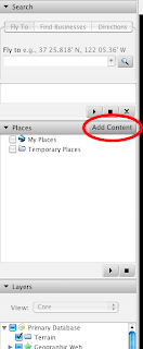
We've introduced a new feature that lets you much more easily search, browse and discover some of the best geographic content directly within Google Earth. Once you've downloaded the latest version of Google Earth, just click the 'Add Content' button in the 'Places' panel, and you can explore our gallery of KML files that have been submitted by users. See what's popular with other Earth users by browsing the 'Popular' category, or take a look at some of our favorite files by choosing 'Featured.'
If you have a KML that you'd like to share, we'd love to include it as well. Please submit any content using this form, and we'll add it to the directory (in a few weeks) so that other people can easily find it.
Become a Google Earth Pro Expert!
A lot of people have been asking about ways they can familiarize themselves with the Google Earth Pro. Finally, we have a great set of classes to point them to.
Now, anyone interested in Google Earth Pro can sign up for a training class at one of the many course locations. For more information, check out this post on the Google SketchUp blog. And don't forget -- SketchUp training classes are offered too!
We look forward to seeing your progress.
Now Playing: YouTube videos in Google Earth
I love watching videos on YouTube. Every once in a while I'll see something so good that it makes me stop and wonder where it was recorded or how I can find more videos from that particular location. For instance, just the other day I stumbled upon a video of a man playing a guitar with his feet. The person who uploaded the video to YouTube geotagged it, so I was able to track the guitarist back to Balboa Park in San Diego, California.
Now you can find YouTube videos connected to specific locations right in Google Earth. Our new browseable layer of geotagged videos works a lot like our Google Book Search layer, only it shows you the locations referenced in specific videos instead of books. Let's say you're jetting off to Paris. Before you go, you can watch the sunset filmed from the top floor of the Eiffel Tower, among other clips of popular spots in the City of Lights.
You'll find this new layer in the 'Featured Content' folder in the left-side panel of Google Earth. Just click on the 'YouTube' button, and icons will begin to appear all over the globe. You can search for videos of your favorite places or browse videos of your dream vacation destination. More videos will appear as you zoom into a particular place. And you have the option of either playing them in Google Earth or viewing them on YouTube.
We've spent countless hours browsing these videos, and we look forward to seeing what other geotagged videos are to come. But we should warn you that if you do turn on this layer, you might not get any work done today! Take our word for it.
Wednesday, October 10, 2007
Wrapping up Our Third Summer of Code
We just wrapped up our third Summer of Code, and as with 2006 we invited mentors from all successful organizations to Google for our annual Mentor Summit. We spent all day Saturday with our colleagues from the open source community sharing knowledge to improve Summer of Code, fostering collaboration and, of course, having fun! Our attendees proposed and led sessions, unconference style, from "How Do You Transfer an Itch?" to "The Stick, the Carrot and Sushi." Marty once again treated everyone to a day of free association and tinker toys in Casablanca.
Here's the obligatory group photo, and as you can see we've picked up a few more friends since last year.
You might also want to check out some pre and post summit pics from Bart, Seb and Wolf.
Congratulations once again to all of our students and mentors for another stellar showing in Summer of Code. Keep your eye on the program blog in the coming weeks for notes from the mentor summit and more success stories from our students and mentoring organizations.
(Photo Credit: Robert Kaye)
Community maps in your search results
It's no secret that our users are the true experts on local information. Sometimes a tip from a friend or a friendly local can make all the difference.
Over the last year, we've been working hard to organize this local wisdom; we've sifted through millions of My Maps, KML files and other information created by all of you in the geoweb. Starting today, community maps will be available in search results on Google Maps. Now you can find cool places to visit, go for a hike, walk your dog, or take a date using the help of other Google users.
The blue markers ('community maps') indicate relevant user-contributed results for your search. You can click on the 'see more community maps' link either in the community box or at the bottom of the page to see more user-contributed results.
Tuesday, October 9, 2007
More Street View cities to explore (Update)
As some of you may have already heard, we've added Street View imagery to six new cities in Google Maps: Chicago, Portland, Pittsburgh, Phoenix, Tucson and Philadelphia. To celebrate, we've created a new video that follows the adventures of our lovable Street View character as he karaokes his way through our newly added cities.
If you're interested in making your own Street View video, don't forget to right-click and download this free MP3. Reply with a video response for a chance to be featured as a YouTube karaoke star! Bonus points go to those of you who have the best Street View lyrics and costume.
And if you haven't already yet, be sure to check out our new Street View additions. We think they'll have you singing in the streets, too!
More Street View cities to explore
For those of you who have been eagerly awaiting new cities to be added to Street View in Google Maps, your patience is about to pay off. Today, we're announcing the addition of Street View imagery in not one or two but six new cities!
Now you can check out 360-degree views of Chicago, Pittsburgh, Philadelphia, Phoenix, Portland and Tucson. As an added bonus, the images in Phoenix, Tucson and parts of Chicago are all in high resolution.
But wait! There's more. Ever wish you could pan up to the very top of a 50-story skyscraper using Street View? Well, prepare yourself for some serious sightseeing; we've introduced the ability to pan up in most new cities.
To get started, check out this incredible view of Sears Tower. (Remember to use caution if you have a fear of heights!)